IMAGES TAKEN NEAR TO
Bridell, CARDIGAN, SA43 3DE
Introduction
This page details the photographs taken nearby to SA43 3DE by members of the Geograph project.
The Geograph project started in 2005 with the aim of publishing, organising and preserving representative images for every square kilometre of Great Britain, Ireland and the Isle of Man.

There are currently over 7.5m images from over14,400 individuals and you can help contribute to the project by visiting https://www.geograph.org.uk
Image Map (Loading...)


Getting Data...Please wait
Leaflet Map data © OpenStreetMap
Images are licensed for reuse under creativecommons.org/licenses/by-sa/2.0
Notes
- Clicking on the map will re-center to the selected point.
- The higher the marker number, the further away the image location is from the centre of the postcode.
Image Listing (7 Images Found)
Images are licensed for reuse under creativecommons.org/licenses/by-sa/2.0
Image
Details
Distance
1
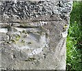
Ordnance Survey Cut Mark
This damaged OS cut mark can be found on the west face of St David's Church. It marks a point 54.395m above mean sea level.
Image: © Adrian Dust
Taken: 17 Feb 2020
0.04 miles
3
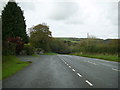
A478 heading for Bridell
A view from the layby of the A478 heading downhill for Bridell.
Image: © Martyn Harries
Taken: 9 Nov 2013
0.15 miles
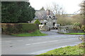
4
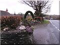
Impressive Topiary Arch
Many years of growing and trimming has produced this very nice topiary arch in the garden of a bungalow at Bridell on the A478.
Image: © chris whitehouse
Taken: 13 Feb 2012
0.18 miles
5
House on southern edge of Bridell
'Cwmwsni' off lay-by on A478.
Image: © M J Roscoe
Taken: 28 Nov 2021
0.18 miles
6
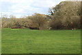
Roadside field opposite Bryn-y-Wawr
Field next to A478 on southern edge of Bridell.
Image: © M J Roscoe
Taken: 28 Nov 2021
0.19 miles
7
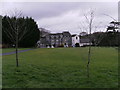
Plas-y-Bridell.
Plas-y-Bridell Nursing Home on the A478 road at Bridell, close to Pen-y-bryn village.
Image: © chris whitehouse
Taken: 13 Feb 2012
0.19 miles