IMAGES TAKEN NEAR TO
Castle Street, CARDIGAN, SA43 3AF
Introduction
This page details the photographs taken nearby to Castle Street, SA43 3AF by members of the Geograph project.
The Geograph project started in 2005 with the aim of publishing, organising and preserving representative images for every square kilometre of Great Britain, Ireland and the Isle of Man.

There are currently over 7.5m images from over14,400 individuals and you can help contribute to the project by visiting https://www.geograph.org.uk
Image Map (Loading...)


Getting Data...Please wait
Leaflet Map data © OpenStreetMap
Images are licensed for reuse under creativecommons.org/licenses/by-sa/2.0
Notes
- Clicking on the map will re-center to the selected point.
- The higher the marker number, the further away the image location is from the centre of the postcode.
Image Listing (516 Images Found)
Images are licensed for reuse under creativecommons.org/licenses/by-sa/2.0
Image
Details
Distance
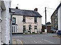
1
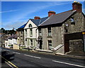
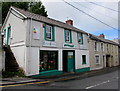
Castle Street houses, Cardigan
Viewed across the B4546 Castle Street, looking towards the right turn into Station Road.
Image: © Jaggery
Taken: 26 Jun 2015
0.02 miles
2
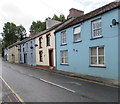
Row of houses, Castle Street, Cardigan
Viewed across the B4546 Castle Street. At the end of the row, Cardigan Windows shop http://www.geograph.org.uk/photo/4542000 faces Station Road.
Image: © Jaggery
Taken: 26 Jun 2015
0.02 miles
3
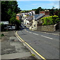
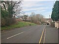
Descent into Cardigan
The B4546 Castle Street descends towards low-lying ground alongside the Afon Teifi.
Image: © Jaggery
Taken: 26 Jun 2015
0.02 miles
4
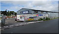
Jewson entrance, Cardigan
Builders merchants yard entrance from Station Road.
Image: © Jaggery
Taken: 26 Jun 2015
0.03 miles
5
Cardigan Windows shop, Cardigan
Cardigan Windows (Glass & Glazing) shop is located in The Workshops, Castle Street, opposite Station Road.
Image: © Jaggery
Taken: 26 Jun 2015
0.03 miles
6
Castle Street, Cardigan
There used to be a roadside house at this location which bore an Ordnance Survey benchmark.
The mark was used on the Warrington to Pembroke Docks line of the First Primary Levelling of England & Wales in 1851-1852. It was levelled with a height of 56.910' above OD (Liverpool). Description: 749. Mark on corner of James Thomas's house ; 2.75 ft. above surface. Page 536 of the abstract: https://www.bench-marks.org.uk/abstract/ew1gl/1GLA_536.png
The mark was included on the Aberaeron to Carmarthen secondary line of the Second Geodetic Levelling of England & Wales in 1927-1928. It was levelled with a height of 57.08' above OD (Newlyn). Abstract A 471: http://discovery.nationalarchives.gov.uk/details/r/C11178815 [OS 54/136].
Image: © N Scott
Taken: 1 Mar 2022
0.04 miles
7
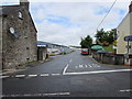
Station Road, Cardigan
Viewed across Castle Street.
Station Road formerly led to Cardigan railway station, where passenger services ceased in 1962.
Image: © Jaggery
Taken: 26 Jun 2015
0.05 miles
8
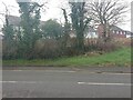
Site of culvert, Castle Street, Cardigan
There used to be a culvert at this location, which was probably removed during the building of the housing estate behind. It bore an Ordnance Survey rivet benchmark:
Height: 18.2971m OD (Newlyn). Mark verified by the Ordnance Survey in 1974. Description: NBM RIVET CUL SW SIDE RD PRODN SE FACE HATFIELD. 0.2m above ground. 3rd Order BM. SN 1789 4559
Image: © N Scott
Taken: 1 Mar 2022
0.05 miles
9
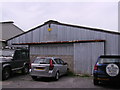
Cardigan agricultural market building
One of a range of buildings that is Cardigan Mart, Station Road, enlarged sign Image
Image: © chris whitehouse
Taken: 11 Aug 2012
0.05 miles
10
The Cardigan Mercantile Company, Castle Street, Aberteifi/ Cardigan
Seen from St Dogmaels Road
Image: © Stefan Czapski
Taken: 27 Jun 2011
0.06 miles