IMAGES TAKEN NEAR TO
Rhoshill, CARDIGAN, SA43 2TU
Introduction
This page details the photographs taken nearby to SA43 2TU by members of the Geograph project.
The Geograph project started in 2005 with the aim of publishing, organising and preserving representative images for every square kilometre of Great Britain, Ireland and the Isle of Man.

There are currently over 7.5m images from over14,400 individuals and you can help contribute to the project by visiting https://www.geograph.org.uk
Image Map (Loading...)


Getting Data...Please wait
Leaflet Map data © OpenStreetMap
Images are licensed for reuse under creativecommons.org/licenses/by-sa/2.0
Notes
- Clicking on the map will re-center to the selected point.
- The higher the marker number, the further away the image location is from the centre of the postcode.
Image Listing (4 Images Found)
Images are licensed for reuse under creativecommons.org/licenses/by-sa/2.0
Image
Details
Distance
1
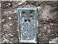
Ordnance Survey Flush Bracket S0665
This can be found on the wall of Rhos-Hill.
For more detail see : http://www.bench-marks.org.uk/bm234
Image: © Peter Wood
Taken: 21 May 2013
0.17 miles
2
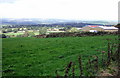
Wenfo and the Teifi valley
Wenfo Farm (buildings on the right) stands on the northern scarp of the Mynydd Preseli and commands an impressive view over the Teifi valley.
Looking northeast in this image.
Image: © Natasha Ceridwen de Chroustchoff
Taken: 28 Aug 2007
0.19 miles
3
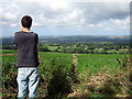
Capturing the view
Stopping to look at the view is well nigh irresistible at this point - due north towards the hills of mid-Wales.
Image: © Natasha Ceridwen de Chroustchoff
Taken: 28 Aug 2007
0.22 miles
4
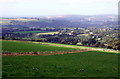
Aberteifi over the fields
The road between Rhoshill in the east and Eglwyswrw in the west runs along the northern Preseli escarpment providing spectacular views over the Teifi valley. In this one, looking NNW, the town of Cardigan and the Teifi estuary can be seen in the distance.
Image: © Natasha Ceridwen de Chroustchoff
Taken: 28 Aug 2007
0.23 miles