IMAGES TAKEN NEAR TO
Llon Cardi Bach, CARDIGAN, SA43 2TF

Introduction

This page details the photographs taken nearby to Llon Cardi Bach, SA43 2TF by members of the Geograph project.

The Geograph project started in 2005 with the aim of publishing, organising and preserving representative images for every square kilometre of Great Britain, Ireland and the Isle of Man.

There are currently over 7.5m images from over14,400 individuals and you can help contribute to the project by visiting https://www.geograph.org.uk

Image Map


Images are licensed for reuse under creativecommons.org/licenses/by-sa/2.0
Notes
  • Clicking on the map will re-center to the selected point.
  • The higher the marker number, the further away the image location is from the centre of the postcode.

Image Listing (104 Images Found)

Images are licensed for reuse under creativecommons.org/licenses/by-sa/2.0
  • ...
Image
Details
Distance
1
Old pub in Cilgerran
Looks closed to me. Shame.
Image: © Jeremy Bolwell Taken: 1 Sep 2019
0.04 miles
2
Former Pendre Inn
This possible 17th century building was a pub until recently Image
Image: © Sandy Gerrard Taken: 26 Sep 2022
0.04 miles
3
Penuel Baptist Chapel, Cilgerran
It was difficult to tell whether this is currently active.
Image: © Bill Boaden Taken: 25 Aug 2011
0.05 miles
4
Penuel vestry
The Welsh Baptist chapel next door to the vestry was built in 1820 and this vestry added in 1908, It is now a private residence.
Image: © Eirian Evans Taken: 6 Apr 2022
0.05 miles
5
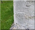
Ordnance Survey Cut Mark
This OS cut mark can be found on the west angle of the chapel. It marks a point 50.081m above mean sea level.
Image: © Adrian Dust Taken: 19 Feb 2020
0.05 miles
6
Old chapel in Cilgerran
Penuel Baptist chapel looks to have suffered since this Geograph photo in 2011 by Bill Boaden https://www.geograph.org.uk/photo/2591923
Image: © Jeremy Bolwell Taken: 1 Sep 2019
0.05 miles
7
The Pendre Inn, Cilgerran
A pub in the current Good Beer Guide, and going by the signs outside, it has reasonably priced beer.
Image: © Bill Boaden Taken: 25 Aug 2011
0.06 miles
8
Quarry houses on Rhiw Dolbadau, Cilgerran
Image: © Dylan Moore Taken: 29 Apr 2022
0.09 miles
9
High Street at the Village Stores, Cilgerran
The lane to the left goes down to the riverside car park.
Image: © Humphrey Bolton Taken: 25 Oct 2016
0.10 miles
10
The Coracle Centre, Cilgerran
The covered part at the front has a series of information boards. There are public conveniences in the building.
Image: © Humphrey Bolton Taken: 25 Oct 2016
0.11 miles
  • ...