IMAGES TAKEN NEAR TO
Maesyderi, CARDIGAN, SA43 2NW
Introduction
This page details the photographs taken nearby to Maesyderi, SA43 2NW by members of the Geograph project.
The Geograph project started in 2005 with the aim of publishing, organising and preserving representative images for every square kilometre of Great Britain, Ireland and the Isle of Man.

There are currently over 7.5m images from over14,400 individuals and you can help contribute to the project by visiting https://www.geograph.org.uk
Image Map
Images are licensed for reuse under creativecommons.org/licenses/by-sa/2.0
Notes
- Clicking on the map will re-center to the selected point.
- The higher the marker number, the further away the image location is from the centre of the postcode.
Image Listing (12 Images Found)
Images are licensed for reuse under creativecommons.org/licenses/by-sa/2.0
Image
Details
Distance
1
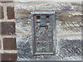
Ordnance Survey Flush Bracket S0664
This can be found on the wall of Llechryd Primary School.
For more detail see : http://www.bench-marks.org.uk/log?bm_key=20639
Image: © Peter Wood
Taken: 22 May 2013
0.07 miles
2
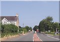
A484 at Llechryd
From junction with Maesyderi
Image: © John Firth
Taken: 10 Jul 2013
0.07 miles
3
Llwynadda Chapel, Llechryd
Non-conformist chapel with the date 1829, but originally established in 1791.
Image: © Natasha Ceridwen de Chroustchoff
Taken: 11 Jan 2007
0.09 miles
4
Ysgol Gynradd Llechryd
Modern primary school beside the main road in this long strung-out village.
The banner at the front refers to a literacy scheme 'We have Read a Million Words'.
Image: © Natasha Ceridwen de Chroustchoff
Taken: 26 May 2007
0.10 miles
5
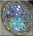
Millennium plaque
Charming mosaic dated 2000 and set in the north wall of the village school. It depicts the children's faces and the birds and beasts to be found in the vicinity, including kingfisher, sewin, otter and even someone in a coracle.
The motto means 'Effort and Success'.
Image: © Natasha Ceridwen de Chroustchoff
Taken: 26 May 2007
0.12 miles

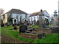
7

Ordnance Survey Cut Mark
This OS cut mark can be found on the west face of St Tydfil's Church. It marks a point 22.785m above mean sea level.
Image: © Adrian Dust
Taken: 20 Sep 2016
0.16 miles
8
Eglwys Llechryd Church
Panoramig o Eglwys Llechryd wedi ei dynnu o Neuadd Cwrwgl Llechryd.
-----
Panoramic of Llechryd Church taken from the Coracle Hall at Llechryd.
Image: © G Williams
Taken: 18 Mar 2009
0.17 miles
9
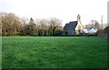
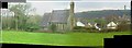
Llechryd Church
Church of the Holy Cross, seen here across an adjacent field, stands beside the A484 north of the Teifi bridge. The church is a C19 replacement of an earlier one.
Image: © Natasha Ceridwen de Chroustchoff
Taken: 11 Jan 2007
0.19 miles
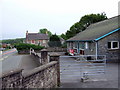
10
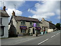
Saith Seren/Seven Stars, Llechryd
One of two pubs in the village, both in the main street.
Image: © Natasha Ceridwen de Chroustchoff
Taken: 19 Jun 2010
0.21 miles