IMAGES TAKEN NEAR TO
Penllwyndu, CARDIGAN, SA43 2LY
Introduction
This page details the photographs taken nearby to Penllwyndu, SA43 2LY by members of the Geograph project.
The Geograph project started in 2005 with the aim of publishing, organising and preserving representative images for every square kilometre of Great Britain, Ireland and the Isle of Man.

There are currently over 7.5m images from over14,400 individuals and you can help contribute to the project by visiting https://www.geograph.org.uk
Image Map (Loading...)


Getting Data...Please wait
Leaflet Map data © OpenStreetMap
Images are licensed for reuse under creativecommons.org/licenses/by-sa/2.0
Notes
- Clicking on the map will re-center to the selected point.
- The higher the marker number, the further away the image location is from the centre of the postcode.
Image Listing (2 Images Found)
Images are licensed for reuse under creativecommons.org/licenses/by-sa/2.0
Image
Details
Distance
1
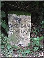
Old Milestone by the B4570, Llangoedmor parish
Cardigan tombstone by the B4570, in parish of Llangoedmor (Ceredigion District), West of Penllwyndu Inn, on verge under hedge, Southeast side of road.
Inscription reads:-
TO
CARDIGAN
4 MILES
Carved benchmark on lower face.
Grade II listed by Cadw.
Reference Number: 14792 https://cadwpublic-api.azurewebsites.net/reports/listedbuilding/FullReport?lang=&id=14792
Surveyed
Milestone Society National ID: CRD_CALA04
Image: © Milestone Society
Taken: Unknown
0.09 miles
2
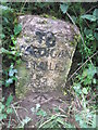
Milestone - Cardigan 4
There is an OS cut mark on the milestone. It marks a point 113.841m above mean sea level.
Image: © Adrian Dust
Taken: 3 May 2015
0.09 miles