IMAGES TAKEN NEAR TO
Llangoedmor, CARDIGAN, SA43 2LB
Introduction
This page details the photographs taken nearby to SA43 2LB by members of the Geograph project.
The Geograph project started in 2005 with the aim of publishing, organising and preserving representative images for every square kilometre of Great Britain, Ireland and the Isle of Man.

There are currently over 7.5m images from over14,400 individuals and you can help contribute to the project by visiting https://www.geograph.org.uk
Image Map (Loading...)


Getting Data...Please wait
Leaflet Map data © OpenStreetMap
Images are licensed for reuse under creativecommons.org/licenses/by-sa/2.0
Notes
- Clicking on the map will re-center to the selected point.
- The higher the marker number, the further away the image location is from the centre of the postcode.
Image Listing (15 Images Found)
Images are licensed for reuse under creativecommons.org/licenses/by-sa/2.0
Image
Details
Distance
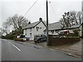
2
The track to Treforgan, Llangoedmor
The end of the wall East of the track to Treforgan used to bear an Ordnance Survey benchmark:
The mark was used on the Brecknock to Cardigan line of the First Primary Levelling of England & Wales in 1856. It was levelled with a height of 143.181' above OD (Liverpool). Description: 120. Mark on end of approach wall at junction of avenue, North side of road ; 2.61 ft. above surface. Page 572 of the abstract: https://www.bench-marks.org.uk/abstract/ew1gl/1GLA_572.png
Image: © N Scott
Taken: 22 Mar 2023
0.07 miles
4
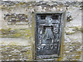
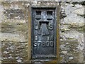
Ordnance Survey Flush Bracket S7800
This can be found on the wall of St Cynllo's Church.
For more detail see : http://www.bench-marks.org.uk/bm13163
Image: © Peter Wood
Taken: 21 May 2013
0.14 miles
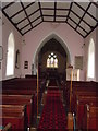
5
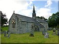
St Cynllo's Church
The parish church of St Cynllo is a grade II* listed building.
Image: © Rude Health
Taken: 12 Sep 2015
0.14 miles
6
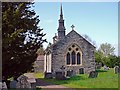
Parish Church: Llangoedmor
The OS map shows this as a church with a spire, but it's really just a typical Welsh belfry-church with the spike from a Prussian army helmet stuck on the top.
Image: © Dylan Moore
Taken: 5 May 2008
0.14 miles
7
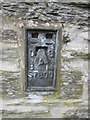
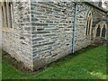
Ordnance Survey Flush Bracket (S7800)
This OS Flush Bracket can be found on the north face of St Cynllo's Church. It marks a point 40.531m above mean sea level.
Image: © Adrian Dust
Taken: 3 May 2015
0.14 miles
8
OSBM Flush Bracket S7800 - Llangoedmor, St. Cynllo's Church
Ordnance Survey Benchmark (OSBM) used for levelling height above Ordnance Datum (OD).
Height (1954): 40.531m OD (Newlyn). Mark verified by the Ordnance Survey in 1974. Description: FLBR S7800 ST CYNLLOS CH 2.1M NE ANG N FACE. 0.6m above ground. 1st Order BM. (Listed as a cut mark in the current OS database)
The bracket was used on the Haverford West to Cardigan line (G077) of the Third Geodetic Levelling of England & Wales in 1954. Abstract G 65: http://discovery.nationalarchives.gov.uk/SearchUI/details?Uri=C11264473 [OS 54/754]
Context: Image
Image: © N Scott
Taken: 22 Mar 2023
0.14 miles
9
OSBM Flush Bracket S7800 - Llangoedmor, St. Cynllo's Church
Ordnance Survey Benchmark (OSBM) used for levelling height above Ordnance Datum (OD).
Height (1954): 40.531m OD (Newlyn). Mark verified by the Ordnance Survey in 1974. Description: FLBR S7800 ST CYNLLOS CH 2.1M NE ANG N FACE. 0.6m above ground. 1st Order BM. (Listed as a cut mark in the current OS database)
The bracket was used on the Haverford West to Cardigan line (G077) of the Third Geodetic Levelling of England & Wales in 1954. Abstract G 65: http://discovery.nationalarchives.gov.uk/SearchUI/details?Uri=C11264473 [OS 54/754]
Close-up: Image
Image: © N Scott
Taken: 22 Mar 2023
0.14 miles
10
Eglwys Sant Cynllo, Llangoedmor / St Cynllo Church, Llangoedmor
Image: © David Jones
Taken: 24 Feb 2014
0.15 miles