IMAGES TAKEN NEAR TO
Aberporth, CARDIGAN, SA43 2HT
Introduction
This page details the photographs taken nearby to SA43 2HT by members of the Geograph project.
The Geograph project started in 2005 with the aim of publishing, organising and preserving representative images for every square kilometre of Great Britain, Ireland and the Isle of Man.

There are currently over 7.5m images from over14,400 individuals and you can help contribute to the project by visiting https://www.geograph.org.uk
Image Map
Images are licensed for reuse under creativecommons.org/licenses/by-sa/2.0
Notes
- Clicking on the map will re-center to the selected point.
- The higher the marker number, the further away the image location is from the centre of the postcode.
Image Listing (3 Images Found)
Images are licensed for reuse under creativecommons.org/licenses/by-sa/2.0
Image
Details
Distance
1
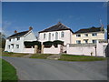
Old chapel and houses
For once this old 19th century chapel seems to still actually be a chapel.
Image: © Jeremy Bolwell
Taken: 21 Sep 2011
0.03 miles
2
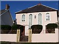
Brynmair Chapel
Brynmair Congregational chapel, erected in 1897 replacing the original chapel that was built here in 1833.
Image: © Cered
Taken: 6 Sep 2005
0.05 miles