IMAGES TAKEN NEAR TO
Aberporth, CARDIGAN, SA43 2DD
Introduction
This page details the photographs taken nearby to SA43 2DD by members of the Geograph project.
The Geograph project started in 2005 with the aim of publishing, organising and preserving representative images for every square kilometre of Great Britain, Ireland and the Isle of Man.

There are currently over 7.5m images from over14,400 individuals and you can help contribute to the project by visiting https://www.geograph.org.uk
Image Map (Loading...)


Getting Data...Please wait
Leaflet Map data © OpenStreetMap
Images are licensed for reuse under creativecommons.org/licenses/by-sa/2.0
Notes
- Clicking on the map will re-center to the selected point.
- The higher the marker number, the further away the image location is from the centre of the postcode.
Image Listing (84 Images Found)
Images are licensed for reuse under creativecommons.org/licenses/by-sa/2.0
Image
Details
Distance
1
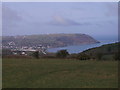
Aberporth and Cribach Bay
Photo taken from minor road from Tan-y-groes
Image: © chris whitehouse
Taken: 10 Mar 2012
0.02 miles
4
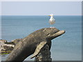
Dolphin statue at Aberporth
This statue, designed and carved by Paul Clarke, was unveiled in Summer 2001. It was funded by the Prince's Trust Antur Aberporth. In the ten years since its installation it has lost much of its original colour; compare with Image
Image: © Bob Jones
Taken: 4 Jul 2011
0.04 miles
5
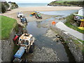
Beach scene at Aberporth
Beaches are never boring to look at. Here the Nant Gilwen joins the sea.
Image: © Jeremy Bolwell
Taken: 21 Sep 2011
0.05 miles
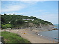
6
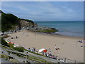
Traeth Dolwen & Carreg Ogof, Aberporth
West Beach on a Bank Holiday weekend; the tide is close to high water.
Image: © M J Roscoe
Taken: 28 Aug 2016
0.05 miles
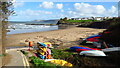
7
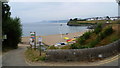
Aberporth - West beach
West beach on a warm, sunny, spring afternoon.
Image: © Richard Law
Taken: 1 Jun 2011
0.05 miles
8
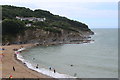
Coastal scenery at Aberporth, Ceredigion
A great view back up the coastline here towards Llangrannog.
Image: © Jeremy Bolwell
Taken: 26 Jul 2014
0.05 miles
9
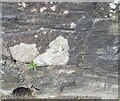
Ordnance Survey Cut Mark
This OS cut mark can be found on the bridge SW side of the road. It marks a point 8.710m above mean sea level.
Image: © Adrian Dust
Taken: 7 Jun 2021
0.05 miles
10
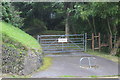
Gated entrance to track, Aberporth
The bottom of the sign on the locked gate states that the entrance is in constant use, but the chain on the gate and the barrier in front of the gate would seem to indicate that it is rarely used!
Image: © M J Roscoe
Taken: 28 Aug 2016
0.06 miles