IMAGES TAKEN NEAR TO
Cambrian Way, CARDIGAN, SA43 2BW
Introduction
This page details the photographs taken nearby to Cambrian Way, SA43 2BW by members of the Geograph project.
The Geograph project started in 2005 with the aim of publishing, organising and preserving representative images for every square kilometre of Great Britain, Ireland and the Isle of Man.

There are currently over 7.5m images from over14,400 individuals and you can help contribute to the project by visiting https://www.geograph.org.uk
Image Map
Images are licensed for reuse under creativecommons.org/licenses/by-sa/2.0
Notes
- Clicking on the map will re-center to the selected point.
- The higher the marker number, the further away the image location is from the centre of the postcode.
Image Listing (5 Images Found)
Images are licensed for reuse under creativecommons.org/licenses/by-sa/2.0
Image
Details
Distance
1
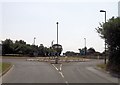
West Wales Airport roundabout
From Aberporth road
Image: © John Firth
Taken: 10 Jul 2013
0.09 miles
2

Air Traffic Control Tower, Aberporth (ICAO code EGFA)
Home of John, the friendliest controller in the UK!
Image: © John Chorley
Taken: 8 Jun 2008
0.13 miles
3
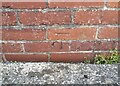
Ordnance Survey Cut Mark
This OS cut mark can be found on the brick building at Pen-y-bryn Farm. It marks a point 126.604m above mean sea level.
Image: © Adrian Dust
Taken: 7 Jun 2021
0.14 miles
4
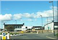
Parc Aberporth
Parc Aberporth is a business park particularly for those in the defence and aerospace related industries, it was formerly an RAF base. It is situated on the B4333 just off the A487 at Blaenannerch.
Image: © Cered
Taken: 16 Sep 2005
0.19 miles
5
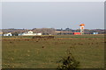
Terminal buildings, West Wales Airport
Viewed from Rhyd, Blaenannerch; the line of the runway can just be discerned in front of the buildings.
Image: © M J Roscoe
Taken: 24 Feb 2018
0.24 miles