IMAGES TAKEN NEAR TO
Blaenporth, CARDIGAN, SA43 2AX
Introduction
This page details the photographs taken nearby to SA43 2AX by members of the Geograph project.
The Geograph project started in 2005 with the aim of publishing, organising and preserving representative images for every square kilometre of Great Britain, Ireland and the Isle of Man.

There are currently over 7.5m images from over14,400 individuals and you can help contribute to the project by visiting https://www.geograph.org.uk
Image Map
Images are licensed for reuse under creativecommons.org/licenses/by-sa/2.0
Notes
- Clicking on the map will re-center to the selected point.
- The higher the marker number, the further away the image location is from the centre of the postcode.
Image Listing (3 Images Found)
Images are licensed for reuse under creativecommons.org/licenses/by-sa/2.0
Image
Details
Distance
1
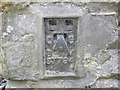
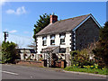
Ordnance Survey Flush Bracket S7794
This can be found on the wall of the old Smithy.
For more detail see : http://www.bench-marks.org.uk/log?bm_key=15262
Image: © Peter Wood
Taken: 22 May 2013
0.01 miles
2
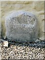
Old Milestone, Blaennant
The milestone has been removed from its original location and is now in a cottage wall, down a cul-de-sac. Carved stone.
Inscription reads: Card VI / TO / Lanp XXII
Milestone Society National ID: CRD_CALA06A
Image: © Chris Woodard
Taken: 30 Apr 2011
0.04 miles