IMAGES TAKEN NEAR TO
Penparc, CARDIGAN, SA43 2AF
Introduction
This page details the photographs taken nearby to SA43 2AF by members of the Geograph project.
The Geograph project started in 2005 with the aim of publishing, organising and preserving representative images for every square kilometre of Great Britain, Ireland and the Isle of Man.

There are currently over 7.5m images from over14,400 individuals and you can help contribute to the project by visiting https://www.geograph.org.uk
Image Map (Loading...)


Getting Data...Please wait
Leaflet Map data © OpenStreetMap
Images are licensed for reuse under creativecommons.org/licenses/by-sa/2.0
Notes
- Clicking on the map will re-center to the selected point.
- The higher the marker number, the further away the image location is from the centre of the postcode.
Image Listing (3 Images Found)
Images are licensed for reuse under creativecommons.org/licenses/by-sa/2.0
Image
Details
Distance
1
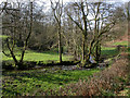
Nant Arberth
The picturesque wooded valley of the Nant Arberth. To the right of the stream, the lane leads to the Troedyrhiw holiday cottages.
Image: © Colin Chambers
Taken: 26 Mar 2005
0.20 miles
2
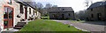
Troedyrhiw Holiday Cottages
These cottages form part of a 13-acre smallholding nestling in the picturesque wooded valley of the Nant Arberth. The formerly derelict farm buildings were converted into holiday accommodation over the period 1994-98. More information can be found at http://www.troedyrhiw.com/aboutus.htm.
Image: © Colin Chambers
Taken: 26 Mar 2005
0.22 miles
3
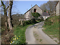
Entrance to Troedyrhiw Holiday Cottages
The holiday cottages - originally farm buildings - are situated at the end of the lane that leads through the Nant Arberth valley.
Image: © Colin Chambers
Taken: 26 Mar 2005
0.22 miles