IMAGES TAKEN NEAR TO
Penparc, CARDIGAN, SA43 1RE
Introduction
This page details the photographs taken nearby to SA43 1RE by members of the Geograph project.
The Geograph project started in 2005 with the aim of publishing, organising and preserving representative images for every square kilometre of Great Britain, Ireland and the Isle of Man.

There are currently over 7.5m images from over14,400 individuals and you can help contribute to the project by visiting https://www.geograph.org.uk
Image Map
Images are licensed for reuse under creativecommons.org/licenses/by-sa/2.0
Notes
- Clicking on the map will re-center to the selected point.
- The higher the marker number, the further away the image location is from the centre of the postcode.
Image Listing (5 Images Found)
Images are licensed for reuse under creativecommons.org/licenses/by-sa/2.0
Image
Details
Distance
1
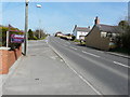
Looking east-northeast along the A487
The nearer house on the right, standing on the corner of a cul-de-sac called Brynawel, was derelict.
Image: © John Baker
Taken: 22 Mar 2015
0.14 miles
2
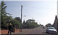
Crossroads, Penparc
Looking uphill along Heol-y-Felin.
Image: © John Baker
Taken: 22 Mar 2015
0.14 miles
3
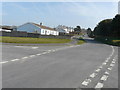
Approaching garage at Penparc from Glasdir junction
Image: © John Firth
Taken: 11 Jul 2013
0.17 miles
4
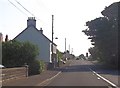
Pen Parc on A487
At Feidr Tywod junction
Image: © John Firth
Taken: 11 Jul 2013
0.18 miles
5
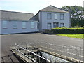
Penyparc Baptist Chapel
First built in 1769. Rebuilt in 1838.
Image: © Roger W Haworth
Taken: 20 Sep 2007
0.20 miles