IMAGES TAKEN NEAR TO
Penparc, CARDIGAN, SA43 1QZ
Introduction
This page details the photographs taken nearby to SA43 1QZ by members of the Geograph project.
The Geograph project started in 2005 with the aim of publishing, organising and preserving representative images for every square kilometre of Great Britain, Ireland and the Isle of Man.

There are currently over 7.5m images from over14,400 individuals and you can help contribute to the project by visiting https://www.geograph.org.uk
Image Map (Loading...)


Getting Data...Please wait
Leaflet Map data © OpenStreetMap
Images are licensed for reuse under creativecommons.org/licenses/by-sa/2.0
Notes
- Clicking on the map will re-center to the selected point.
- The higher the marker number, the further away the image location is from the centre of the postcode.
Image Listing (3 Images Found)
Images are licensed for reuse under creativecommons.org/licenses/by-sa/2.0
Image
Details
Distance
1
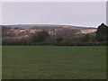
Sand pit at Penparc
Penparc area is mostly sand and huge "dunes" are there, this one is Cardigan Sand and Gravel Co. site. A long way from the coast.
Image: © chris whitehouse
Taken: 10 Mar 2012
0.11 miles
2
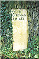
Old Milestone by the A487, below Banc-y-Warren, Cardigan parish
Cardigan low profile top by the A487, in parish of Cardigan (Ceredigion District), below Banc-y-Warren, Eastern end of the old road (now farm track), in bank, South side of road.
Inscription reads:-
TO
CARDIGAN
2 MILES
Surveyed
Milestone Society National ID: CRD_CAAY02
Image: © Milestone Society
Taken: Unknown
0.19 miles
3
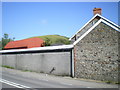
Warren Farm, with Banc-y-Warren beyond
Situated right beside the A487, Warren Farm rather blocks the view of the hill of the same name.
Image: © Richard Law
Taken: 2 Jun 2011
0.23 miles