IMAGES TAKEN NEAR TO
CARDIGAN, SA43 1QY
Introduction
This page details the photographs taken nearby to SA43 1QY by members of the Geograph project.
The Geograph project started in 2005 with the aim of publishing, organising and preserving representative images for every square kilometre of Great Britain, Ireland and the Isle of Man.

There are currently over 7.5m images from over14,400 individuals and you can help contribute to the project by visiting https://www.geograph.org.uk
Image Map (Loading...)


Getting Data...Please wait
Leaflet Map data © OpenStreetMap
Images are licensed for reuse under creativecommons.org/licenses/by-sa/2.0
Notes
- Clicking on the map will re-center to the selected point.
- The higher the marker number, the further away the image location is from the centre of the postcode.
Image Listing (4 Images Found)
Images are licensed for reuse under creativecommons.org/licenses/by-sa/2.0
Image
Details
Distance
1
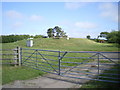
Covered reservoir beside the A487
A water storage facility at Ael y Bryn
Image: © Richard Law
Taken: 2 Jun 2011
0.14 miles
3
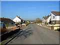
Houses on Caemorgan Road
Pretty much the opposite viewpoint to that in http://www.geograph.org.uk/photo/689120
Image: © Richard Law
Taken: 2 Jun 2011
0.23 miles