IMAGES TAKEN NEAR TO
Ferwig, CARDIGAN, SA43 1PX
Introduction
This page details the photographs taken nearby to SA43 1PX by members of the Geograph project.
The Geograph project started in 2005 with the aim of publishing, organising and preserving representative images for every square kilometre of Great Britain, Ireland and the Isle of Man.

There are currently over 7.5m images from over14,400 individuals and you can help contribute to the project by visiting https://www.geograph.org.uk
Image Map (22 Images)


Getting Data...Please wait
Leaflet Map data © OpenStreetMap
Images are licensed for reuse under creativecommons.org/licenses/by-sa/2.0
Notes
- Clicking on the map will re-center to the selected point.
- The higher the marker number, the further away the image location is from the centre of the postcode.
Image Listing (22 Images Found)
Images are licensed for reuse under creativecommons.org/licenses/by-sa/2.0
Image
Details
Distance
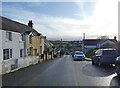
2
The main road through Y Ferwig
Of interest is the circular yellow AA sign, attached to the wall of the nearest building, which spells Ferwig as Verwig.
Image: © John Baker
Taken: 22 Mar 2015
0.04 miles
4
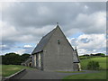
The church of St. Pedrog, Y Fervig
The west tower was demolished 1968 and replaced by this rather unattractive west wall.
Image: © Jonathan Thacker
Taken: 2 Jul 2015
0.05 miles
5
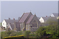
Parish Church: Y Ferwig / Verwig
A misty day: after a mini-heatwave, sea mist envelopes the coast.
Image: © Dylan Moore
Taken: 5 May 2008
0.06 miles
6
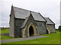
St Pedrog's Church
The church dates from 1842 when an application for a grant was made to the Church Building Society. It was built in 1853-4 to designs of Henry Woodyer, and is considered to be a poor example of his work by an otherwise esteemed Victorian architect. It is constructed of cut grey Cilgerran stone and Bath stone tracery, with tall steeply-pitched slate roofs. It consists of nave and narrower chancel, north vestry and gabled south-west porch. The church was built against the tower of a medieval church. The tower became unsafe and was completely demolished in 1976. A new west wing was built in its place.
Image: © Rude Health
Taken: 9 Sep 2015
0.06 miles
7
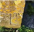
Ordnance Survey Cut Mark
This OS cut mark can be found on the east face of St Pedrog's Church. It marks a point 96.728m above mean sea level.
Image: © Adrian Dust
Taken: 17 Feb 2020
0.06 miles
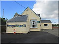
8
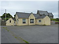
Ysgol y Ferwig Infant & Primary School
The school closed with effect from the end of 2006, before which there were roughly 8 children on the register. The building remains available as a community centre for the area.
Image: © Richard Law
Taken: 29 May 2011
0.07 miles
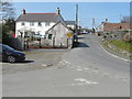
9
Old AA Sign in Y Ferwig
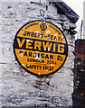
Old AA Sign located on the gable end of a cottage on the southwest side of the road at the south end of Y Ferwig, 2½ miles north of Cardigan. Y Ferwig community.
This is the Circular, village name on black band, no Motor Union symbol or name type, dating from 1923, showing distances Gwbert on Sea 1½ Cardigan 2½ London 235¼.
There were five series of AA signs, mostly dating from 1923 and made by Francis & Co / Franco in Deptford, London. The village name and distance to London were displayed.
Milestone Society National ID: CRD-VERW
Image: © Milestone Society
Taken: Unknown
0.07 miles
10
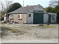
Derelict garage
This once sold fuel for vehicles as there are the remains of the pumps’ bases in front of the building. The sign, above the main door, advertises John Player Special.
Image: © John Baker
Taken: 22 Mar 2015
0.08 miles