IMAGES TAKEN NEAR TO
Gwbert, CARDIGAN, SA43 1PW
Introduction
This page details the photographs taken nearby to SA43 1PW by members of the Geograph project.
The Geograph project started in 2005 with the aim of publishing, organising and preserving representative images for every square kilometre of Great Britain, Ireland and the Isle of Man.

There are currently over 7.5m images from over14,400 individuals and you can help contribute to the project by visiting https://www.geograph.org.uk
Image Map
Images are licensed for reuse under creativecommons.org/licenses/by-sa/2.0
Notes
- Clicking on the map will re-center to the selected point.
- The higher the marker number, the further away the image location is from the centre of the postcode.
Image Listing (8 Images Found)
Images are licensed for reuse under creativecommons.org/licenses/by-sa/2.0
Image
Details
Distance
1
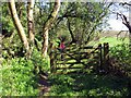
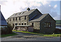
Llwybr Ceffyl Felin Bedr Bridleway
Llwybr ceffyl yn arwain tuag at Felin Bedr.
A bridleway heading towards Felin Bedr (trans. Peter's Mill).
Image: © Alan Richards
Taken: 18 Apr 2015
0.18 miles
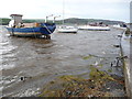
2
Boats on the Teifi estuary near Waungelod, Y Ferwig
Image: © Dylan Moore
Taken: 25 Jan 2009
0.22 miles
3
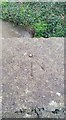
Ordnance Survey Rivet
This OS rivet can be found on the NE parapet of the stream. It marks a point 4.889m above mean sea level.
Image: © Adrian Dust
Taken: 17 Feb 2020
0.22 miles
4
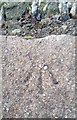
Ordnance Survey Rivet
This OS rivet can be found on the wall SW side of Coronation Drive. It marks a point 4.375m above mean sea level.
Image: © Adrian Dust
Taken: 17 Feb 2020
0.23 miles
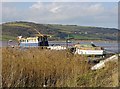
6
Part of the Teifi Estuary
A fine set of craft are moored here, including Lynx, Alpha One Two and Octavia. All with interesting histories I am sure.
Image: © Jeremy Bolwell
Taken: 2 Nov 2011
0.24 miles
7
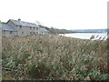
Reed bed beside the Teifi Estuary
A small reed bed stands beside the waters of the Afon Teifi here.
Image: © Jeremy Bolwell
Taken: 2 Nov 2011
0.25 miles
8
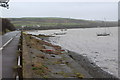
Afon Teifi upstream, by Coronation Drive
The river comes close to the B4548 here; the Wales Coast Path runs along the pavement.
Image: © M J Roscoe
Taken: 24 Feb 2020
0.25 miles