IMAGES TAKEN NEAR TO
North Road, CARDIGAN, SA43 1LS
Introduction
This page details the photographs taken nearby to North Road, SA43 1LS by members of the Geograph project.
The Geograph project started in 2005 with the aim of publishing, organising and preserving representative images for every square kilometre of Great Britain, Ireland and the Isle of Man.

There are currently over 7.5m images from over14,400 individuals and you can help contribute to the project by visiting https://www.geograph.org.uk
Image Map (Loading...)


Getting Data...Please wait
Leaflet Map data © OpenStreetMap
Images are licensed for reuse under creativecommons.org/licenses/by-sa/2.0
Notes
- Clicking on the map will re-center to the selected point.
- The higher the marker number, the further away the image location is from the centre of the postcode.
Image Listing (369 Images Found)
Images are licensed for reuse under creativecommons.org/licenses/by-sa/2.0
Image
Details
Distance
1
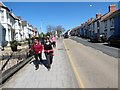
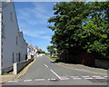
Heol y Gogledd / North Road
Cerddwyr yn dilyn Heol y Gogledd yn Aberteifi.
Walkers following North Road in Cardigan.
Image: © Alan Richards
Taken: 18 Apr 2015
0.02 miles
2
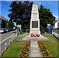
Cardigan War Memorial
Erected in 1923 at the southern edge of Victoria Gardens, the War Memorial is
a smaller version of the Cenotaph in Whitehall, London. Grade II listed in 1992.
Image: © Jaggery
Taken: 26 Jun 2015
0.04 miles
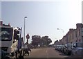
4
Spar Store, Cardigan
North Road shop viewed from Victoria Gardens.
Image: © Jaggery
Taken: 26 Jun 2015
0.05 miles
5
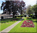
Victoria Gardens, Cardigan
Occupying a triangular site alongside North Road, Victoria Gardens was officially opened
on June 20th 1897 to celebrate the 60th year of Queen Victoria’s reign (Diamond Jubilee).
Image: © Jaggery
Taken: 26 Jun 2015
0.06 miles
6
Site of the Pavilion Cinema, Napier Gardens, Cardigan
The site is now occupied by Pavilion Court.
Image: © N Scott
Taken: 6 Mar 2022
0.06 miles
7
Napier Gardens, Cardigan
Viewed across Napier Street.
Image: © Jaggery
Taken: 26 Jun 2015
0.06 miles
8
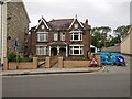
2-4 North Road, Cardigan
There used to be an Ordnance Survey benchmark at the East (right) angle of the wall in front of 4 North Road, which replaced the PA bolt on the gate-pier of the County Gaol, to the West.
Benchmark height: 49.3' OD (Liverpool).
The mark was included on the Aberaeron to Carmarthen secondary line of the Second Geodetic Levelling of England & Wales in 1927-1928. It was levelled with a height of 49.39' above OD (Newlyn). Abstract A 471: http://discovery.nationalarchives.gov.uk/details/r/C11178815 [OS 54/136].
The mark was, in turn, replaced by a mark on the wall in front of Highbury, to the West, close to the site of the original mark.
Image: © N Scott
Taken: 26 Jun 2022
0.06 miles
9
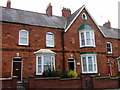
Priory Terrace brickwork
It's likely this was designed to display the products of the local brickworks for the proprietor Mr Woodward, whose own home included a tower that enabled him to spy on his employees.
The architectural details are as follows:
Red brick with extensive dressings in moulded or pressed brick, centre house is gabled and advanced, one-window with door to left, the rest 2-window and all 2 storeys. Upper windows are 4-pane sashes with notched brick segmental heads, slate sills and painted wood boards with incised crosses over window heads. Ground floors each have a canted bay with hipped metal clad roofs, but centre house has 2-storey bay in centre and door to left. Doors are all 2-panel, with notched brick segmental pointed arches and carved heads to varied designs as keystones. Centre house has bargeboarded gable and small pointed attic light. Red brick ridge stacks.
Image: © Natasha Ceridwen de Chroustchoff
Taken: 24 Aug 2007
0.07 miles
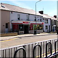
10
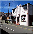
Teifi Furniture & Carpets shop in Cardigan
Viewed across Napier Street.
Image: © Jaggery
Taken: 26 Jun 2015
0.07 miles