IMAGES TAKEN NEAR TO
Greenfield Row, CARDIGAN, SA43 1LB
Introduction
This page details the photographs taken nearby to Greenfield Row, SA43 1LB by members of the Geograph project.
The Geograph project started in 2005 with the aim of publishing, organising and preserving representative images for every square kilometre of Great Britain, Ireland and the Isle of Man.

There are currently over 7.5m images from over14,400 individuals and you can help contribute to the project by visiting https://www.geograph.org.uk
Image Map (Loading...)


Getting Data...Please wait
Leaflet Map data © OpenStreetMap
Images are licensed for reuse under creativecommons.org/licenses/by-sa/2.0
Notes
- Clicking on the map will re-center to the selected point.
- The higher the marker number, the further away the image location is from the centre of the postcode.
Image Listing (613 Images Found)
Images are licensed for reuse under creativecommons.org/licenses/by-sa/2.0
Image
Details
Distance
1
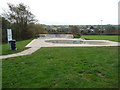
Skate park in Cardigan
Popular I'm sure with BMX riders and skateboarders.
Image: © Jeremy Bolwell
Taken: 2 Nov 2011
0.04 miles
2
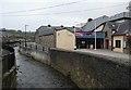
Theatr Mwldan, Bath House Road, Cardigan
The part on the left, with ventilators on the roof, is the former slaughterhouse of 1858-8, designed by R J Withers. It became a theatre in 1985. The larger buildings on the right were built in 2002-4, designed by LAWRAY of Cardiff. The stream is called the Mwldan river. (From The Buildings of Wales - Camarthenshire and Ceredigion)
Image: © Humphrey Bolton
Taken: 26 Jan 2010
0.05 miles
3
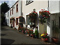
Cottages by the Mwldan stream
Look charming now but this was once an area of wretched poverty with big families crammed into these little dwellings.
Image: © Natasha Ceridwen de Chroustchoff
Taken: 10 Oct 2009
0.05 miles
4
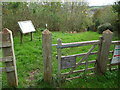
Entrance to Coed Mwldan, Cardigan
A Woodland Trust / Coed Cadw site in the town.
Image: © Jeremy Bolwell
Taken: 2 Nov 2011
0.05 miles
5
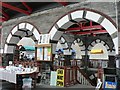
Guildhall Market
This is the upper floor of the market inside the Guildhall.
Image: © Rob Burke
Taken: 9 Sep 2005
0.06 miles
6
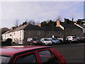
Old houses of Cardigan
Not sure if these dwellings are in College Row? But in front of them is this car park.
Image: © chris whitehouse
Taken: 12 Dec 2012
0.06 miles
7

Road closed
See Image for reason of "Road Closed".
Image: © chris whitehouse
Taken: 12 Dec 2012
0.06 miles
8
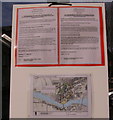
Emergency road closure
Notice for road closure showing alternative routes for traffic, I presume the stone wall adjacent to the furthest house is "falling down" as there is a busy road above it. The notice says "Unsafe structure adjacent to the highway" at Greenfield Square.
Image: © chris whitehouse
Taken: 12 Dec 2012
0.06 miles
9

Wheelhub of Russian cannon
Inscription as it appears on one of the hubs. The other shows the date, 1823.
An explanatory plate on the cannon notes that it was called 'Shvalov's Edinrag' or unicorn.
The cannon can be seen in its entirety here Image
Image: © Natasha Ceridwen de Chroustchoff
Taken: 10 Feb 2007
0.06 miles
10

Canolfan Teifi
Rear entrance to shopping centre, building on right is lower part of Cardigan indoor market building.
Image: © chris whitehouse
Taken: 10 Mar 2012
0.07 miles