IMAGES TAKEN NEAR TO
The Strand, CARDIGAN, SA43 1EX
Introduction
This page details the photographs taken nearby to The Strand, SA43 1EX by members of the Geograph project.
The Geograph project started in 2005 with the aim of publishing, organising and preserving representative images for every square kilometre of Great Britain, Ireland and the Isle of Man.

There are currently over 7.5m images from over14,400 individuals and you can help contribute to the project by visiting https://www.geograph.org.uk
Image Map (Loading...)


Getting Data...Please wait
Leaflet Map data © OpenStreetMap
Images are licensed for reuse under creativecommons.org/licenses/by-sa/2.0
Notes
- Clicking on the map will re-center to the selected point.
- The higher the marker number, the further away the image location is from the centre of the postcode.
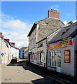
Image Listing (908 Images Found)
Images are licensed for reuse under creativecommons.org/licenses/by-sa/2.0
Image
Details
Distance
1

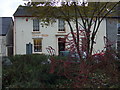
The Strand, Cardigan
View from the southeast tower of Cardigan Castle walls, with the parish church and hospital in the distance.
Image: © Dylan Moore
Taken: 30 Jul 2015
0.01 miles
2
Tivy-side dragon
Metalwork dragon outside the office of the Tivy-side Advertiser, the local newspaper whose symbol it is.
Image: © Natasha Ceridwen de Chroustchoff
Taken: 10 Dec 2008
0.01 miles
3
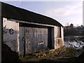
Cardigan Sea Scouts
Building that looks unused now, the Sea Scouts are in decline also? Small slipway into the Afon Teifi.
Image: © chris whitehouse
Taken: 12 Dec 2012
0.02 miles
4
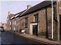
Carriers Lane
Part of the Cardigan one way system, the old building in the centre used to be the Cardigan and Tivyside Advertiser print room, now a listed building along with the offices in St Mary's Street round the corner.
Image: © chris whitehouse
Taken: 12 Dec 2012
0.02 miles
5
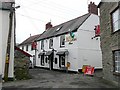
The Angel Hotel, Cardigan
This looks like an old coaching inn, with an archway to the yard at the back. The 'eyebrows' over the windows are a distinctive feature. The narrow street leads to the Red Lion, but was completely blocked when this image was taken.
Image: © Humphrey Bolton
Taken: 26 Jan 2010
0.02 miles
6
The Red Lion, Cardigan
The road to the right was closed even to pedestrians - drainage work I think. It normally leads to the Angel Hotel.
Image: © Humphrey Bolton
Taken: 26 Jan 2010
0.02 miles
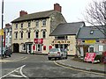
7
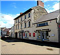
Angel Hotel, Cardigan
36 St Mary Street. Red boards show bistro & bar, pool tables, accommodation, Internet access.
Image: © Jaggery
Taken: 26 Jun 2015
0.02 miles
8
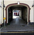
Archway entrance to GABS night club, Cardigan
GABS is Angel Hotel's nightclub, suitable for many kinds of events. Private functions up to 500 people can be accommodated in the nightclub with a further 250 by opening up the space into the main bar area. June 2015 nightclub opening hours are 10pm-2am on Fridays and Saturdays (and Sundays before a Bank Holiday Monday, when the club is open till 3am).
Image: © Jaggery
Taken: 26 Jun 2015
0.02 miles
9
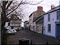
St. Mary's Street
Due to the road improvements years ago, this street was "cut in half", the right hand building was the offices of Cardigan and Tivyside Advertiser, further away the Angle Hotel. The street continues behind me up to the High Street.
Image: © chris whitehouse
Taken: 12 Dec 2012
0.02 miles
10
Seyran's Pizza, Cardigan
Fast food takeaway (pizzas, kebabs, burgers, wraps etc) at 38 St Mary Street.
Angel Hotel http://www.geograph.org.uk/photo/4543649 is next door.
Image: © Jaggery
Taken: 26 Jun 2015
0.02 miles