IMAGES TAKEN NEAR TO
William Street, CARDIGAN, SA43 1EL
Introduction
This page details the photographs taken nearby to William Street, SA43 1EL by members of the Geograph project.
The Geograph project started in 2005 with the aim of publishing, organising and preserving representative images for every square kilometre of Great Britain, Ireland and the Isle of Man.

There are currently over 7.5m images from over14,400 individuals and you can help contribute to the project by visiting https://www.geograph.org.uk
Image Map (Loading...)


Getting Data...Please wait
Leaflet Map data © OpenStreetMap
Images are licensed for reuse under creativecommons.org/licenses/by-sa/2.0
Notes
- Clicking on the map will re-center to the selected point.
- The higher the marker number, the further away the image location is from the centre of the postcode.
Image Listing (770 Images Found)
Images are licensed for reuse under creativecommons.org/licenses/by-sa/2.0
Image
Details
Distance
1
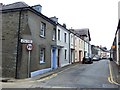
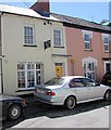
William Street/ Stryd William, Cardigan/ Aberteifi
A little street of (mostly) Georgian cottages, with the Bethania Chapel part-way along, on the left. The cottages are very modest in scale, but there are some quite fancy architectural details to be seen.
The view here is west, from the corner of Feidrfair.
Image: © Stefan Czapski
Taken: 27 Jun 2011
0.01 miles
2
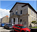
Bethania Baptist Chapel, William Street, Cardigan
Bethania Baptist Chapel was built in the Classical style in 1846-1847.
One of the best examples of a Classical chapel in the area, the building is Grade II* Listed.
Image: © Jaggery
Taken: 26 Jun 2015
0.01 miles
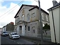
4
West along William Street, Cardigan
From the corner of Feidrfair. Bethania Baptist Chapel http://www.geograph.org.uk/photo/4541913 is ahead on the left.
Image: © Jaggery
Taken: 26 Jun 2015
0.02 miles
5
Vanity Hair Fashions in Cardigan
Hairdressers at 26 William Street.
Image: © Jaggery
Taken: 26 Jun 2015
0.02 miles
6

Georgian doorway in William Street/ Stryd William, Cardigan/ Aberteifi
A very grand Classical doorway for what is otherwise a modest little Georgian cottage. I can't help wondering who these little dwellings were built for. Local shopkkeepers would, I suspect, have lived over their shops - so perhaps the first inhabitants of Stryd William were port officials. Whoever they were, they were putting on airs, in a down-to-earth place like Aberteifi.
Image: © Stefan Czapski
Taken: 27 Jun 2011
0.02 miles
7
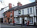
Two more Pendre pubs
The Commercial Hotel and The Hope and Anchor stand side by side across the street from Tabernacle Chapel. These are traditional type pubs which hark back Cardigan's former importance as a trading port and market town.
Image: © Natasha Ceridwen de Chroustchoff
Taken: 24 Jul 2007
0.03 miles
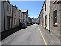
8
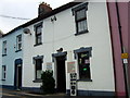
Locksmith in Stryd William
William Street is a narrow turning off Pendre, lined by terraced housing along the north side. This useful shop also does shoe repairs.
Image: © Natasha Ceridwen de Chroustchoff
Taken: 26 Oct 2009
0.03 miles
9

Ordnance Survey Cut Mark
This damaged OS cut mark can be found on No18 William Street. It marks a point 8.998m above mean sea level.
Image: © Adrian Dust
Taken: 3 May 2015
0.03 miles
10

Ordnance Survey Benchmark - Cardigan, 18 William St.
Ordnance Survey Benchmark (OSBM) used for levelling height above Ordnance Datum (OD).
Height: 8.9977m OD (Newlyn). Mark verified by the Ordnance Survey in 1975. Description: HO NO18 WILLIAM ST SE ANG S FACE. 0.2m above ground. 3rd Order BM.
Context: Image
Image: © N Scott
Taken: 4 Jun 2016
0.03 miles