IMAGES TAKEN NEAR TO
Maesglas, CARDIGAN, SA43 1AZ
Introduction
This page details the photographs taken nearby to Maesglas, SA43 1AZ by members of the Geograph project.
The Geograph project started in 2005 with the aim of publishing, organising and preserving representative images for every square kilometre of Great Britain, Ireland and the Isle of Man.

There are currently over 7.5m images from over14,400 individuals and you can help contribute to the project by visiting https://www.geograph.org.uk
Image Map
Images are licensed for reuse under creativecommons.org/licenses/by-sa/2.0
Notes
- Clicking on the map will re-center to the selected point.
- The higher the marker number, the further away the image location is from the centre of the postcode.
Image Listing (24 Images Found)
Images are licensed for reuse under creativecommons.org/licenses/by-sa/2.0
Image
Details
Distance
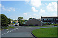
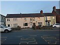
2
Houses in Cardigan/Aberteifi
Houses on Maesglas in Cardigan/Aberteifi during a sunset.
Image: © Pebble
Taken: 24 Oct 2022
0.08 miles
3
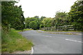
Melin Y Coed
This is a short leafy dead end road on the northern edge of the town that leads to a row of modern detached houses.
Image: © Nigel Mykura
Taken: 29 Jun 2015
0.11 miles
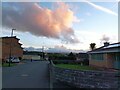
4
View towards transmitter mast from Tesco car park
Image: © Jeff Gogarty
Taken: 2 Oct 2019
0.12 miles
5
8-11 Newtown, Aberystwyth Road, Cardigan
There used to be a small roadside building at this location which bore an Ordnance Survey benchmark on its North-west face, at the North angle, which replaced the pivot benchmark near the road junction, to the South-west.
Benchmark height: 113.9' OD (Liverpool)
The mark was included on the Aberaeron to Carmarthen secondary line of the Second Geodetic Levelling of England & Wales in 1927-1928. It was levelled with a height of 114.05' above OD (Newlyn). Abstract A 471: http://discovery.nationalarchives.gov.uk/details/r/C11178815 [OS 54/136].
The mark was, in turn, replaced by a rivet on the wall behind the gate-pier, at Delfan, South-west of the junction.
Image: © N Scott
Taken: 22 Jul 2022
0.18 miles
6
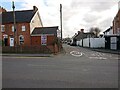
Junction of Feidr Henffordd, New Town, Cardigan
Henffordd Road became a dead-end road when it was bisected by the Cardigan bypass in 1980. There used to be a culvert at this junction, which bore an Ordnance Survey pivot benchmark:
The mark was used on the Warrington to Pembroke Docks line of the First Primary Levelling of England & Wales in 1851-1852. It was levelled with a height of 105.075' above OD (Liverpool). Description: 744. Mark on flag over gullet at junction of roads, East side of road ; 0.34 ft. below centre of road. Page 536 of the abstract: https://www.bench-marks.org.uk/abstract/ew1gl/1GLA_536.png
Image: © N Scott
Taken: 6 Mar 2022
0.18 miles
7
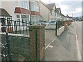
Wall, Delfan, Aberystwyth Road, Cardigan
The wall behind this gate-pier used to bear an Ordnance Survey rivet benchmark.
Height: 32.5222m OD (Newlyn). Mark verified by the Ordnance Survey in 1975. Description: NBM RIVET WALL DELFAN. 0.6m above ground. 3rd Order BM.
Image: © N Scott
Taken: 6 Mar 2022
0.19 miles
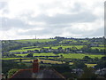
8
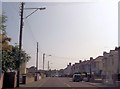
Aberystwyth Road Cardigan
Heading towards Tesco
Image: © John Firth
Taken: 10 Jul 2013
0.19 miles
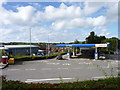
10
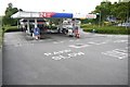
Tesco Petrol Station , Cardigan
This supermarket filling station is opposite Ger y Mein on the Aberystwyth Rd next to the towns Subaru car dealership.
Image: © Nigel Mykura
Taken: 29 Jun 2015
0.21 miles