IMAGES TAKEN NEAR TO
Maesglas, CARDIGAN, SA43 1AT
Introduction
This page details the photographs taken nearby to Maesglas, SA43 1AT by members of the Geograph project.
The Geograph project started in 2005 with the aim of publishing, organising and preserving representative images for every square kilometre of Great Britain, Ireland and the Isle of Man.

There are currently over 7.5m images from over14,400 individuals and you can help contribute to the project by visiting https://www.geograph.org.uk
Image Map
Images are licensed for reuse under creativecommons.org/licenses/by-sa/2.0
Notes
- Clicking on the map will re-center to the selected point.
- The higher the marker number, the further away the image location is from the centre of the postcode.
Image Listing (19 Images Found)
Images are licensed for reuse under creativecommons.org/licenses/by-sa/2.0
Image
Details
Distance
1
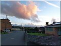
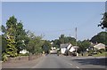
Houses in Cardigan/Aberteifi
Houses on Maesglas in Cardigan/Aberteifi during a sunset.
Image: © Pebble
Taken: 24 Oct 2022
0.07 miles
2
View towards transmitter mast from Tesco car park
Image: © Jeff Gogarty
Taken: 2 Oct 2019
0.08 miles
3
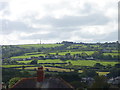
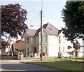
Melin Y Coed
This is a short leafy dead end road on the northern edge of the town that leads to a row of modern detached houses.
Image: © Nigel Mykura
Taken: 29 Jun 2015
0.12 miles
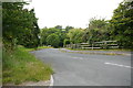
7

Resurfacing of Gwbert Road
Resurfacing work in progress on Gwbert Road.
Image: © Alan Hughes
Taken: 28 Jun 2018
0.17 miles
8
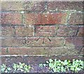
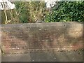
Ordnance Survey Cut Mark
This OS cut mark can be found on the NE parapet of the bridge over the Afon Mwldan. It marks a point 16.345m above mean sea level.
Image: © Adrian Dust
Taken: 17 Feb 2020
0.18 miles
9
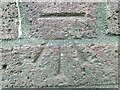
Ordnance Survey Benchmark - Cardigan, Gwbert Road
Ordnance Survey Benchmark (OSBM) used for levelling height above Ordnance Datum (OD).
Height: 16.345m OD (Newlyn). Mark verified by the Ordnance Survey in 1975. Description: NBM BR OVER AFON MWLDAN NE PARA C STR SW FACE. 0.4m above ground. 3rd Order BM.
Context: Image
Image: © N Scott
Taken: 27 Feb 2022
0.18 miles
10
Ordnance Survey Benchmark - Cardigan, Gwbert Road
Ordnance Survey Benchmark (OSBM) used for levelling height above Ordnance Datum (OD).
Height: 16.345m OD (Newlyn). Mark verified by the Ordnance Survey in 1975. Description: NBM BR OVER AFON MWLDAN NE PARA C STR SW FACE. 0.4m above ground. 3rd Order BM.
Close-up: Image
Image: © N Scott
Taken: 27 Feb 2022
0.18 miles