IMAGES TAKEN NEAR TO
Spring Hill, NEWPORT, SA42 0YH
Introduction
This page details the photographs taken nearby to Spring Hill, SA42 0YH by members of the Geograph project.
The Geograph project started in 2005 with the aim of publishing, organising and preserving representative images for every square kilometre of Great Britain, Ireland and the Isle of Man.

There are currently over 7.5m images from over14,400 individuals and you can help contribute to the project by visiting https://www.geograph.org.uk
Image Map
Images are licensed for reuse under creativecommons.org/licenses/by-sa/2.0
Notes
- Clicking on the map will re-center to the selected point.
- The higher the marker number, the further away the image location is from the centre of the postcode.
Image Listing (8 Images Found)
Images are licensed for reuse under creativecommons.org/licenses/by-sa/2.0
Image
Details
Distance
1
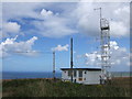
Wireless station above Dinas
I have heard that the first 'Radio Free Euzkadi' broadcast in Basque was made from here, but I have not been able to verify this.
Image: © Natasha Ceridwen de Chroustchoff
Taken: 30 Jul 2006
0.18 miles
2
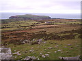
View from Carn Enoch, looking north
The view from the rocky outcrop of Carn Enoch (290m.) shows, in the foreground, scattered stones used for prehistoric enclosures, then bracken covered hillside and rough grazing giving way to improved pasture around the village of Dinas on the A487. In the distance lies Dinas Island, which, despite its name is not separated from the mainland.
Image: © Natasha Ceridwen de Chroustchoff
Taken: 30 Jan 2005
0.18 miles
3
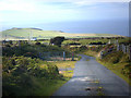
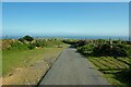
Road from Cwm Gwaun to Dinas Cross
Cattle grid and Radio transmitter visible
Image: © Chris Gunns
Taken: 9 Aug 2007
0.18 miles
5
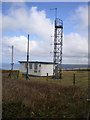
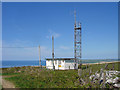
Radio station on Mynydd Dinas
The sign on the gate says, rather unhelpfully, "Government Property, no unauthorised access"
Image: © Richard Law
Taken: 4 Apr 2010
0.20 miles
7
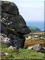
Face of stone
Sleeping giant at Carnsefyll.
Image: © Natasha Ceridwen de Chroustchoff
Taken: 29 Aug 2009
0.24 miles
8
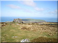
Carnsefyll and Dinas Island
The rocky 'tor' of Carnsefyll, with Dinas Island beyond.
Image: © Richard Law
Taken: 4 Apr 2010
0.25 miles