IMAGES TAKEN NEAR TO
Tir Treharne, NEWPORT, SA42 0RN
Introduction
This page details the photographs taken nearby to Tir Treharne, SA42 0RN by members of the Geograph project.
The Geograph project started in 2005 with the aim of publishing, organising and preserving representative images for every square kilometre of Great Britain, Ireland and the Isle of Man.

There are currently over 7.5m images from over14,400 individuals and you can help contribute to the project by visiting https://www.geograph.org.uk
Image Map
Images are licensed for reuse under creativecommons.org/licenses/by-sa/2.0
Notes
- Clicking on the map will re-center to the selected point.
- The higher the marker number, the further away the image location is from the centre of the postcode.
Image Listing (34 Images Found)
Images are licensed for reuse under creativecommons.org/licenses/by-sa/2.0
Image
Details
Distance
1
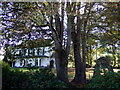
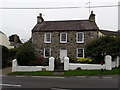
Cotham Lodge
Lovely C19 house facing west towards the sea: it was built as a dower house for the Bowen family of Llwyngwair Manor.
Image: © Natasha Ceridwen de Chroustchoff
Taken: 5 Oct 2007
0.04 miles
2
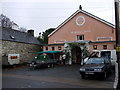
Memorial Hall, Trefdraeth/Newport
The hall was erected in memory of the WW1 dead and there is a list of them inside.
Today it is the venue for the Green Fair. The apparatus on the trailer is a bio-digester which produces methane gas from organic waste.
Image: © Natasha Ceridwen de Chroustchoff
Taken: 15 Nov 2008
0.06 miles
3
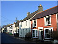
West Street
An attractive mixture of houses lines the street on both sides. Very much in demand but traffic can be a problem. Dropped kerbs allow vehicles to get by in the busy season.
Image: © Natasha Ceridwen de Chroustchoff
Taken: 19 Feb 2008
0.12 miles
4
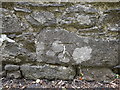
OS benchmark - Trefdraeth, roadside building on West Street
Set low on the wall of a building built into the boundary wall of the road, this OS cutmark was levelled in 1953 at 36.185, above Ordnance Datum Newlyn.
Image: © Richard Law
Taken: 15 Sep 2019
0.13 miles
5

Ordnance Survey Cut Mark
This OS cut mark can be found on the building north side of the road. It marks a point 36.185m above mean sea level.
Image: © Adrian Dust
Taken: 19 Feb 2020
0.13 miles
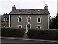
6
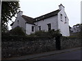
Mount View house, Newport
Grade II listed https://britishlistedbuildings.co.uk/300012523-mount-view-newport#.XZJwvEZKjcs in 1992, Mount View dates from around the middle of the 19th century, and is described in its listing details as "A good example of later C19 houses in Georgian tradition"
Image: © Richard Law
Taken: 15 Sep 2019
0.13 miles
7
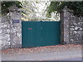
Gatepiers at Cotham Lodge
Part of the entranceway to the impressive Image, these gateposts (and the boundary wall) date from the mid 19th century, and were Grade II listed in 1992.
Image: © Richard Law
Taken: 15 Sep 2019
0.13 miles
8
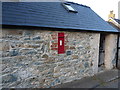
Victorian postbox in an outbuilding
SA42 30 is mounted into the wall of a small outbuilding on the eastern outskirts of Newport.
Image: © Richard Law
Taken: 19 Sep 2019
0.14 miles
9
Cotham Lodge, Newport
Set in its own grounds behind the high stone wall (itself listed), Cotham Lodge dates from the mid 19th century, and was supposedly built for the Bowen family from the nearby Image It attracted a Grade II listing https://britishlistedbuildings.co.uk/300012519-cotham-lodge-newport#.XZWZ20ZKhPY in 1992.
Image: © Richard Law
Taken: 15 Sep 2019
0.14 miles
10
Highway Farmhouse, Newport
Situated on the north side of the main road out of Newport towards Fishguard, Highway Farmhouse was Grade II listed https://britishlistedbuildings.co.uk/300012522-highway-farmhouse-newport#.XZJxdEZKjcs in 1992, and dates originally from the early 19th century. It was unpainted at the time of its listing.
Image: © Richard Law
Taken: 15 Sep 2019
0.15 miles