IMAGES TAKEN NEAR TO
NEWPORT, SA42 0QT
Introduction
This page details the photographs taken nearby to SA42 0QT by members of the Geograph project.
The Geograph project started in 2005 with the aim of publishing, organising and preserving representative images for every square kilometre of Great Britain, Ireland and the Isle of Man.

There are currently over 7.5m images from over14,400 individuals and you can help contribute to the project by visiting https://www.geograph.org.uk
Image Map
Images are licensed for reuse under creativecommons.org/licenses/by-sa/2.0
Notes
- Clicking on the map will re-center to the selected point.
- The higher the marker number, the further away the image location is from the centre of the postcode.
Image Listing (14 Images Found)
Images are licensed for reuse under creativecommons.org/licenses/by-sa/2.0
Image
Details
Distance
1
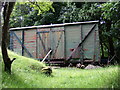
Old railway wagon
This one seems to have been put to horse-related use.
Image: © Natasha Ceridwen de Chroustchoff
Taken: 7 Jul 2008
0.07 miles
2
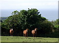
Horses, Trefdraeth/Newport
Pony-trekking and horse-riding on the mountain above is popular here and many small fields and paddocks around the town are given over to equine inhabitants.
Image: © Natasha Ceridwen de Chroustchoff
Taken: 7 Jul 2008
0.13 miles
3
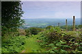
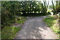
Lon werdd / Green lane
Llwybr caniataol yn dilyn lon werdd / Permissive path following a green lane
Image: © Ian Medcalf
Taken: 14 Jun 2014
0.18 miles
4
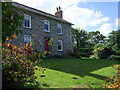
Castle Hill, Trefdraeth/Newport
Attractive old house standing above the castle.
Image: © Natasha Ceridwen de Chroustchoff
Taken: 17 Sep 2010
0.19 miles
5
Road to Castle Hill
Castle Hill appears to be just a housing development in the environs of Newport. It is not immediately near the castle.
Image: © Bill Boaden
Taken: 23 Aug 2011
0.21 miles
6
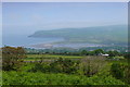
Caeau uwchben Trefdraeth / Fields above Newport
Golygfa lawr i Fae Trefdraeth / A view down to Newport Bay.
Image: © Ian Medcalf
Taken: 14 Jun 2014
0.22 miles
7
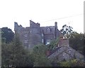
Newport Castle
Newport castle consists of a large gatehouse with two circular towers, the dungeon tower on the southwest and the Hunter's tower on the northwest, the southeast side was protected by a large D-shaped tower.
Image: © Cered
Taken: 22 Sep 2005
0.22 miles
8
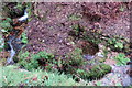
Ffynnon Drieg revealed
Recent clearance of the gulley here has brought to light Ffynnon Drieg, the Treacle Well beside Nant-y-Blodau. The 'well', a shallow reservoir under the bank with a low containing wall beside the stream, was brought to my attention in the 1970 booklet 'Looking Around Newport Pembs'by Islwyn Jenkins, headmaster of the primary school at the time. He set his pupils the task of marking and mapping old footpaths and landmarks around the town and arranged for some of them to clear out this well. He explains that its name refers to the original meaning of treacle as a medicinal balm or healing unguent, the etymology being from the Greek and Latin words for antidote (to the bite of venomous animals.) The only other extant 'treacle well' appears to be the one featured by Lewis Carroll in Alice in Wonderland at Binsey near Oxford http://www.geograph.org.uk/photo/3529229
My previous attempts to locate the well failed because it was concealed by vegetation - this may well happen again so it is satisfying to find it still exists.
Image: © Natasha Ceridwen de Chroustchoff
Taken: 8 Mar 2017
0.23 miles
9

Castell Drefdraeth/Newport castle in summertime
The view up from the crossroads at the top of Market Street shows how the castle dominates the small town below. Its melding of mediaeval and Victorian architecture gives it a curious and romantic appearance. Although it dates back originally to C13 there was considerable destruction and rebuilding over the centuries until Thomas Lloyd of Bronwydd grafted a dwelling house on to the ruins.
The castle remains in private hands and is not open to the public.
Image: © Natasha Ceridwen de Chroustchoff
Taken: 4 Aug 2007
0.23 miles
10
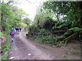
Ger Fountain Hill / Near Fountain Hill
Cerddwyr yn dilyn trac ger anhedd-dy o'r enw Fountain Hill.
Walkers following a track near a property known as Fountain Hill.
Image: © Alan Richards
Taken: 21 May 2017
0.23 miles