IMAGES TAKEN NEAR TO
Cilgwyn, NEWPORT, SA42 0QH
Introduction
This page details the photographs taken nearby to SA42 0QH by members of the Geograph project.
The Geograph project started in 2005 with the aim of publishing, organising and preserving representative images for every square kilometre of Great Britain, Ireland and the Isle of Man.

There are currently over 7.5m images from over14,400 individuals and you can help contribute to the project by visiting https://www.geograph.org.uk
Image Map
Images are licensed for reuse under creativecommons.org/licenses/by-sa/2.0
Notes
- Clicking on the map will re-center to the selected point.
- The higher the marker number, the further away the image location is from the centre of the postcode.
Image Listing (8 Images Found)
Images are licensed for reuse under creativecommons.org/licenses/by-sa/2.0
Image
Details
Distance
2
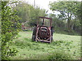
Old farm buildings at Dol-rhanog Uchaf
Image: © Gareth James
Taken: 28 May 2016
0.03 miles
5
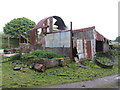
Looking off the lane at D?l-Rhanog Uchaf
Image: © Christopher Hilton
Taken: 1 Jun 2017
0.08 miles
6

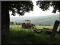
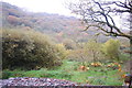
Views across the Cwm
The trees in Cwm Gwaun are sheltered by Carn Ingli, or Angel Mountain as it is known locally.
Image: © Deborah Tilley
Taken: 19 Oct 2008
0.19 miles
7
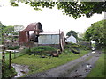
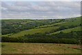
View over Gallt Pen-rhiw
From the road out of the end of Cwm Gwaun heading for Newport.
Image: © Trevor Harris
Taken: 26 Oct 2015
0.20 miles
8
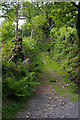
Path climbing away from Pen Rhiw
The path climbs up the south side of Carningli to Carn Edward.
Image: © Christopher Hilton
Taken: 1 Jun 2017
0.22 miles