IMAGES TAKEN NEAR TO
NEWPORT, SA42 0QG
Introduction
This page details the photographs taken nearby to SA42 0QG by members of the Geograph project.
The Geograph project started in 2005 with the aim of publishing, organising and preserving representative images for every square kilometre of Great Britain, Ireland and the Isle of Man.

There are currently over 7.5m images from over14,400 individuals and you can help contribute to the project by visiting https://www.geograph.org.uk
Image Map (10 Images)


Getting Data...Please wait
Leaflet Map data © OpenStreetMap
Images are licensed for reuse under creativecommons.org/licenses/by-sa/2.0
Notes
- Clicking on the map will re-center to the selected point.
- The higher the marker number, the further away the image location is from the centre of the postcode.
Image Listing (10 Images Found)
Images are licensed for reuse under creativecommons.org/licenses/by-sa/2.0
Image
Details
Distance
1
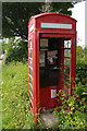
Decommissioned telephone box, Ffordd Cilgwyn, Newport / Trefdraeth
Image: © Christopher Hilton
Taken: 1 Jun 2017
0.08 miles
2
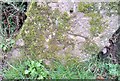
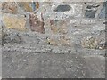
Ordnance Survey Cut Mark
This OS cut mark can be found on the stone at the entrance to Ffordd Glgwyn. It marks a point 110.761m above mean sea level.
Image: © Adrian Dust
Taken: 19 Feb 2020
0.08 miles
3
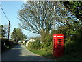
Telephone box southeast of Trefdraeth/Newport
Old-style red phone box some way beyond the town would have been positioned to serve the scattered settlement along and around this quiet road. Hard to guess how much it is used it today but it looks pleasantly traditional in this rural setting.
Image: © Natasha Ceridwen de Chroustchoff
Taken: 23 Oct 2007
0.09 miles
4
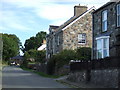
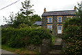
King Street, Newport/Trefdraeth
These houses and cottages on the southeastern edge of the town have a wonderful view towards the estuary and sands. They command extremely high prices, like all the property in this area.
Image: © Natasha Ceridwen de Chroustchoff
Taken: 24 Aug 2006
0.15 miles
5
Last house in the village, above Newport / Trefdraeth
This cottage is the uppermost in a run of scattered houses that climb the hill south-east out of Newport / Trefdraeth. In the 1970s Newport Youth Hostel was up this lane, a long and unforgiving climb from sea level after a day on the coast path, and this may have been it: confirmation one way or another would be welcomed.
Image: © Christopher Hilton
Taken: 1 Jun 2017
0.17 miles
6
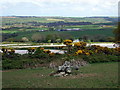
Fields under plastic
Crops sown under the protection of plastic, near Trefdraeth/Newport.
Image: © Natasha Ceridwen de Chroustchoff
Taken: 11 May 2010
0.17 miles
7
Ordnance Survey Cut Mark
This OS cut mark can be found on Belmont SW side of Ffordd Glgwyn. It marks a point 98.789m above mean sea level.
Image: © Adrian Dust
Taken: 5 May 2022
0.18 miles
8
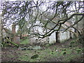
Ruins old and new
Close to the mountain sheepwalk stands the remains of this small farmhouse, probably a couple of hundred years old, with its traditional long, low structure and 'simne fawr' at one end. At some point during the C19 it was replaced by a shoddy new house which stands alongside (left), also derelict. Constructed as a brick shell with pine floor and room partitioning, it has stood up to the elements far less well than its more solidly built predecessor.
Image: © Natasha Ceridwen de Chroustchoff
Taken: 17 Jan 2007
0.22 miles
9
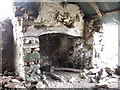
Someone's dream cottage?
This ruined mountain dwelling, described here: Image, still retains an almost intact 'simne fawr' or big chimney, a much sought-after traditional fireplace with a huge beam, useful wall ledges, hooks to hang cooking pots and a view of the sky above.
Image: © Natasha Ceridwen de Chroustchoff
Taken: 17 Jan 2007
0.22 miles
10
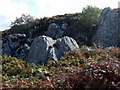
Carn Cwn
Dogs' cairn: a cluster of enormous rocks protruding from the hillside.
Image: © Natasha Ceridwen de Chroustchoff
Taken: 17 Sep 2010
0.24 miles