IMAGES TAKEN NEAR TO
Nevern, NEWPORT, SA42 0NQ
Introduction
This page details the photographs taken nearby to SA42 0NQ by members of the Geograph project.
The Geograph project started in 2005 with the aim of publishing, organising and preserving representative images for every square kilometre of Great Britain, Ireland and the Isle of Man.

There are currently over 7.5m images from over14,400 individuals and you can help contribute to the project by visiting https://www.geograph.org.uk
Image Map (Loading...)


Getting Data...Please wait
Leaflet Map data © OpenStreetMap
Images are licensed for reuse under creativecommons.org/licenses/by-sa/2.0
Notes
- Clicking on the map will re-center to the selected point.
- The higher the marker number, the further away the image location is from the centre of the postcode.
Image Listing (3 Images Found)
Images are licensed for reuse under creativecommons.org/licenses/by-sa/2.0
Image
Details
Distance
1
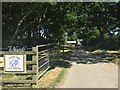
Trefach Farm
Entrance to dairy farm at Trefach.
Image: © Alan Hughes
Taken: 27 Jun 2018
0.05 miles
2
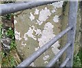
Ordnance Survey Cut Mark
This OS cut mark can be found on the gatepost west side of the road at Tre Fach. It marks a point 95.460m above mean sea level.
Image: © Adrian Dust
Taken: 19 Feb 2020
0.10 miles
3
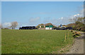
Buildings at Tre-f?ch, Nevern
Tre-fâch = "small farm": one of two of that name in the parish of Nevern.
Image: © Dylan Moore
Taken: 2 May 2016
0.13 miles