IMAGES TAKEN NEAR TO
NEWPORT, SA42 0NP
Introduction
This page details the photographs taken nearby to SA42 0NP by members of the Geograph project.
The Geograph project started in 2005 with the aim of publishing, organising and preserving representative images for every square kilometre of Great Britain, Ireland and the Isle of Man.

There are currently over 7.5m images from over14,400 individuals and you can help contribute to the project by visiting https://www.geograph.org.uk
Image Map (Loading...)


Getting Data...Please wait
Leaflet Map data © OpenStreetMap
Images are licensed for reuse under creativecommons.org/licenses/by-sa/2.0
Notes
- Clicking on the map will re-center to the selected point.
- The higher the marker number, the further away the image location is from the centre of the postcode.
Image Listing (4 Images Found)
Images are licensed for reuse under creativecommons.org/licenses/by-sa/2.0
Image
Details
Distance
1
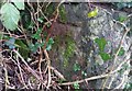
Ordnance Survey Cut Mark
This OS cut mark can be found on the outbuilding at Wynston Farm. It marks a point 57.879m above mean sea level.
Image: © Adrian Dust
Taken: 19 Feb 2020
0.02 miles
2
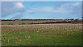
Field near Wynston Farm
Stubble looks like it could have been maize.
Image: © wfmillar
Taken: 20 Feb 2014
0.07 miles
3
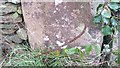
Ordnance Survey Cut Mark
This OS cut mark can be found on the gatepost SE side of the road. It marks a point 51.133m above mean sea level.
Image: © Adrian Dust
Taken: 19 Feb 2020
0.08 miles
4
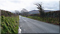
Minor Road to Newport
Berry Hill is just out of sight on the left. The hill on the sky line is Mynydd Carningli above newport.
Image: © wfmillar
Taken: 20 Feb 2014
0.10 miles