IMAGES TAKEN NEAR TO
CRYMYCH, SA41 3RJ
Introduction
This page details the photographs taken nearby to SA41 3RJ by members of the Geograph project.
The Geograph project started in 2005 with the aim of publishing, organising and preserving representative images for every square kilometre of Great Britain, Ireland and the Isle of Man.

There are currently over 7.5m images from over14,400 individuals and you can help contribute to the project by visiting https://www.geograph.org.uk
Image Map
Images are licensed for reuse under creativecommons.org/licenses/by-sa/2.0
Notes
- Clicking on the map will re-center to the selected point.
- The higher the marker number, the further away the image location is from the centre of the postcode.
Image Listing (59 Images Found)
Images are licensed for reuse under creativecommons.org/licenses/by-sa/2.0
Image
Details
Distance
1
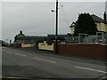
Crymych cemetery
Just to the northwest of the village the sparsely-occupied cemetery lies on the route of the old railway. Behind is a rugby pitch for livelier members of the community with Mynydd Frenni Fawr looming beyond.
Image: © Natasha Ceridwen de Chroustchoff
Taken: 29 Jun 2007
0.08 miles
2
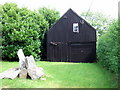
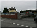
Stone and iron
Stark and simple 'zinc' structure with grassy lawn and heap of boulders, alongside the pavement in Crymych. Could be a barn or a garage? It seems to possess its own special aesthetic.
Image: © Natasha Ceridwen de Chroustchoff
Taken: 28 Aug 2007
0.09 miles
3
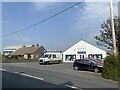
Builders? merchant
Building supplies in Crymych.
Image: © Alan Hughes
Taken: 21 Apr 2021
0.11 miles
4
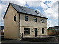
Y Ficerdy, Newport Road, Crymych
Brand new vicarage in Crymych.
Crymych itself has no church, only chapels, but the Church in Wales vicar who lives here is responsible for a group of small churches in the surrounding area.
Image: © Natasha Ceridwen de Chroustchoff
Taken: 28 Aug 2007
0.11 miles
5
Mr. James's new wall!
Agricultural machinery and equipment stockist, on the Newport Road, the old 1950's buildings are still used, but a new yard is to the right, see Image
Image: © chris whitehouse
Taken: 25 Jun 2012
0.11 miles
6
Mr. James's new wall!
Second part of the wall, this agricultural yard has been used for many years but the road boundary was a grassed banking, now removed. See previous photo by Ceridwen Image
Image: © chris whitehouse
Taken: 25 Jun 2012
0.12 miles
7
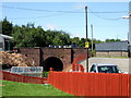
Tunnel at Crymych station
It must have been a thrill to see the Cardigan to Whitland train emerging from this tunnel right into the station at this point.
Now it has become the backdrop to greenhouses and a duckpond, someone having made imaginative use of the old cutting.
Image: © Natasha Ceridwen de Chroustchoff
Taken: 29 Jun 2007
0.13 miles
8

Bara lleol/local bread
One of the stalls at Gwyl Fwyd y Frenni/Frenni Food Festival, Crymych
Image: © Natasha Ceridwen de Chroustchoff
Taken: 28 Aug 2007
0.13 miles
9
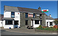
Crymych Arms, Crymych
The pub gave its name to the village and the railway station, and in turn got its name from the farm to the north-west, which was the principal settlement in the area before the early 19th century enclosures.
Image: © Dylan Moore
Taken: 22 Apr 2021
0.14 miles
10
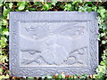
Crymych/Plouveilh twinning plaque
Slate plaque outside the market hall.
Ploveilh (called in French Plomelin) is a small town near Quimper in Finisterre, Brittany.
Many Welsh towns and villages have Breton twins, for obvious reasons.
Image: © Natasha Ceridwen de Chroustchoff
Taken: 28 Aug 2007
0.14 miles