IMAGES TAKEN NEAR TO
Cwmsychpant, LLANYBYDDER, SA40 9XJ
Introduction
This page details the photographs taken nearby to SA40 9XJ by members of the Geograph project.
The Geograph project started in 2005 with the aim of publishing, organising and preserving representative images for every square kilometre of Great Britain, Ireland and the Isle of Man.

There are currently over 7.5m images from over14,400 individuals and you can help contribute to the project by visiting https://www.geograph.org.uk
Image Map
Images are licensed for reuse under creativecommons.org/licenses/by-sa/2.0
Notes
- Clicking on the map will re-center to the selected point.
- The higher the marker number, the further away the image location is from the centre of the postcode.
Image Listing (5 Images Found)
Images are licensed for reuse under creativecommons.org/licenses/by-sa/2.0
Image
Details
Distance
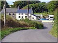
1
Approaching Cymsychbant from the west
Along the A475.
Image: © John Baker
Taken: 22 Mar 2015
0.03 miles
2
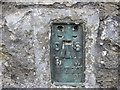
Ordnance Survey Flush Bracket 11777
This can be found at Blaenhirbant Ganol.
For more detail see : http://www.bench-marks.org.uk/log?bm_key=19704
Image: © Peter Wood
Taken: 23 May 2013
0.03 miles