IMAGES TAKEN NEAR TO
Gorsgoch, LLANYBYDDER, SA40 9TE
Introduction
This page details the photographs taken nearby to SA40 9TE by members of the Geograph project.
The Geograph project started in 2005 with the aim of publishing, organising and preserving representative images for every square kilometre of Great Britain, Ireland and the Isle of Man.

There are currently over 7.5m images from over14,400 individuals and you can help contribute to the project by visiting https://www.geograph.org.uk
Image Map (Loading...)


Getting Data...Please wait
Leaflet Map data © OpenStreetMap
Images are licensed for reuse under creativecommons.org/licenses/by-sa/2.0
Notes
- Clicking on the map will re-center to the selected point.
- The higher the marker number, the further away the image location is from the centre of the postcode.
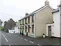
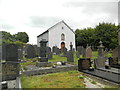
Image Listing (9 Images Found)
Images are licensed for reuse under creativecommons.org/licenses/by-sa/2.0
Image
Details
Distance
1
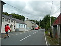
Gorsgoch, main street, looking south-east
Postman delivering letters.
Image: © John Lord
Taken: 16 Aug 2014
0.01 miles
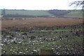
7
Rough pasture, Corsgoch (2)
A slightly different view of the damp pasture in Image
Image: © M J Roscoe
Taken: 25 Feb 2020
0.12 miles
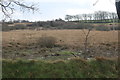
8
Rough pasture, Corsgoch
Damp rushy pasture.
Image: © M J Roscoe
Taken: 25 Feb 2020
0.14 miles
9
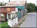
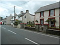
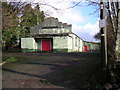
Old Garage
This old garage and its petrol pumps stands on the B4338 in Gorsgoch.
Image: © Cered
Taken: 20 Sep 2005
0.18 miles