IMAGES TAKEN NEAR TO
Pencarreg, LLANYBYDDER, SA40 9QG
Introduction
This page details the photographs taken nearby to SA40 9QG by members of the Geograph project.
The Geograph project started in 2005 with the aim of publishing, organising and preserving representative images for every square kilometre of Great Britain, Ireland and the Isle of Man.

There are currently over 7.5m images from over14,400 individuals and you can help contribute to the project by visiting https://www.geograph.org.uk
Image Map
Images are licensed for reuse under creativecommons.org/licenses/by-sa/2.0
Notes
- Clicking on the map will re-center to the selected point.
- The higher the marker number, the further away the image location is from the centre of the postcode.
Image Listing (5 Images Found)
Images are licensed for reuse under creativecommons.org/licenses/by-sa/2.0
Image
Details
Distance
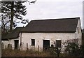
4
Barn near Pencarreg
Pencarreg means "stone headland" and the village is just beyond the rocky outcrop that can be seen on the right.
Image: © Marion Phillips
Taken: 18 Mar 2008
0.12 miles
5
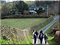
Hen Ysgol Dolgwm / Dolgwm Old School
Cerddwyr yn agosau at hen Ysgol Dolgwm.
Walkers heading in the direction of the former Dolgwm School (trans. valley meadow).
Image: © Alan Richards
Taken: 5 Apr 2009
0.24 miles