IMAGES TAKEN NEAR TO
Tydderwen, PENCADER, SA39 9LY
Introduction
This page details the photographs taken nearby to Tydderwen, SA39 9LY by members of the Geograph project.
The Geograph project started in 2005 with the aim of publishing, organising and preserving representative images for every square kilometre of Great Britain, Ireland and the Isle of Man.

There are currently over 7.5m images from over14,400 individuals and you can help contribute to the project by visiting https://www.geograph.org.uk
Image Map
Images are licensed for reuse under creativecommons.org/licenses/by-sa/2.0
Notes
- Clicking on the map will re-center to the selected point.
- The higher the marker number, the further away the image location is from the centre of the postcode.
Image Listing (4 Images Found)
Images are licensed for reuse under creativecommons.org/licenses/by-sa/2.0
Image
Details
Distance
1
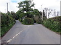
Cyffordd wrth ymyl Ty Dderwen / A junction at Ty Dderwen
Cyffordd wrth ymyl anhedd-dy o'r enw Ty Dderwen.
A junction at a property known at TY Dderwen (trans. oak house).
Image: © Alan Richards
Taken: 1 May 2019
0.05 miles
2
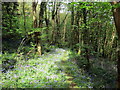
Llwybr ger Rhiw Felen / Path near Rhiw Felen
Clychau'r Gog ar lwybr cyhoeddus ger anhedd-dy o'r enw Rhiw Felen.
Bluebells on a path near a property known as Rhiw Felen (trans. brown hill).
Image: © Alan Richards
Taken: 1 May 2019
0.13 miles
3
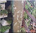
Ordnance Survey Cut Mark
This OS cut mark can be found on the gatepost SW side of the road. It marks a point 124.815m above mean sea level.
Image: © Adrian Dust
Taken: 8 Nov 2019
0.18 miles
4
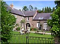
Waunifor Estate - Stable Courtyard
The buildings originally built as stables and coach house for the estate are now holiday cottages
Image: © Joanna
Taken: Unknown
0.22 miles