IMAGES TAKEN NEAR TO
Llanfihangel-Ar-Arth, PENCADER, SA39 9JR
Introduction
This page details the photographs taken nearby to SA39 9JR by members of the Geograph project.
The Geograph project started in 2005 with the aim of publishing, organising and preserving representative images for every square kilometre of Great Britain, Ireland and the Isle of Man.

There are currently over 7.5m images from over14,400 individuals and you can help contribute to the project by visiting https://www.geograph.org.uk
Image Map
Images are licensed for reuse under creativecommons.org/licenses/by-sa/2.0
Notes
- Clicking on the map will re-center to the selected point.
- The higher the marker number, the further away the image location is from the centre of the postcode.
Image Listing (3 Images Found)
Images are licensed for reuse under creativecommons.org/licenses/by-sa/2.0
Image
Details
Distance
2
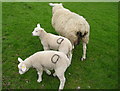
Ewe and Lambs
Sheep are one of the main agricultural products of this area of Wales. These sheep are Texels, a fast growing breed. These were the 9th set of twins born in this flock in 2008. The farmer marks the lambs and their mother (out of sight on her right side) so that he can easily identify each family and reunite them if they get separated.
Image: © Marion Phillips
Taken: 18 Apr 2008
0.24 miles
3
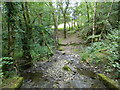
Stream flowing down to the Teifi at Castell Pyr
Image: © John Lord
Taken: 16 Aug 2014
0.24 miles