IMAGES TAKEN NEAR TO
Llanfihangel-Ar-Arth, PENCADER, SA39 9JB
Introduction
This page details the photographs taken nearby to SA39 9JB by members of the Geograph project.
The Geograph project started in 2005 with the aim of publishing, organising and preserving representative images for every square kilometre of Great Britain, Ireland and the Isle of Man.

There are currently over 7.5m images from over14,400 individuals and you can help contribute to the project by visiting https://www.geograph.org.uk
Image Map
Images are licensed for reuse under creativecommons.org/licenses/by-sa/2.0
Notes
- Clicking on the map will re-center to the selected point.
- The higher the marker number, the further away the image location is from the centre of the postcode.
Image Listing (4 Images Found)
Images are licensed for reuse under creativecommons.org/licenses/by-sa/2.0
Image
Details
Distance
1
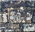
Ordnance Survey Cut Mark
This OS cut mark can be found on the SW parapet of Pont Llanfirangel. It marks a point 81.233m above mean sea level.
Image: © Adrian Dust
Taken: 8 Nov 2019
0.11 miles
2

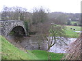
Afon Teifi from Pont Llanfihangel
Looking downstream from the bridge which carries the B4459.
Image: © Stuart Logan
Taken: 7 Oct 2011
0.13 miles
3
Bridge over Teifi at Llanfihangel-ar-arth
Image: © Peter Conroy
Taken: 12 Jan 2007
0.13 miles
4
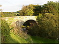
Pont Llanfihangel
On the B4599, a picturesque route.
Image: © Humphrey Bolton
Taken: 30 Sep 2007
0.14 miles