IMAGES TAKEN NEAR TO
Llanllwni, PENCADER, SA39 9EG
Introduction
This page details the photographs taken nearby to SA39 9EG by members of the Geograph project.
The Geograph project started in 2005 with the aim of publishing, organising and preserving representative images for every square kilometre of Great Britain, Ireland and the Isle of Man.

There are currently over 7.5m images from over14,400 individuals and you can help contribute to the project by visiting https://www.geograph.org.uk
Image Map
Images are licensed for reuse under creativecommons.org/licenses/by-sa/2.0
Notes
- Clicking on the map will re-center to the selected point.
- The higher the marker number, the further away the image location is from the centre of the postcode.
Image Listing (4 Images Found)
Images are licensed for reuse under creativecommons.org/licenses/by-sa/2.0
Image
Details
Distance
1
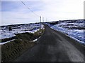
The road across Mynydd Llanllwni
This road takes you to Brechfa and skirts a vast forest that is ideal for cycling and walking. It also stages some sections of the GB Rally.
Image: © Peter Conroy
Taken: 10 Feb 2005
0.05 miles
2
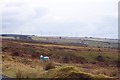
A Blue Sheep
A sheep with its owner's marking of blue - belonging to one of the Graziers of Mynydd Llanllwni common. In the background, some of the ten giant wind turbines near Gwyddgrug, called the Alltwalis wind farm [110 m high]. Although there was a brisk breeze that day, the turbine blades were standing still; not an unusual occurrence. Mynydd Llanllni is the area where another wind farm company want to put 21 more turbines at 127m high.
Image: © Caroline Evans
Taken: 25 Feb 2010
0.14 miles
3
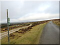
Llwybr yn gadael yr heol / Path exits the road
Llwybr troed cyhoeddus yn gadael yr heol ar lethrau Mynydd Llanllwni.
A public footpath exits the road on the slopes of Mynydd Llanllwni (trans. St Llwni's parish mountain).
Image: © Alan Richards
Taken: 3 Feb 2023
0.17 miles
4
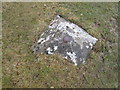
Ordnance Survey Bolt
This OSBM Bolt can be found at the track junction. It marks a point 320.183m above mean sea level.
Image: © Adrian Dust
Taken: 12 Mar 2015
0.20 miles