IMAGES TAKEN NEAR TO
Cae Pensarn, PENCADER, SA39 9EF
Introduction
This page details the photographs taken nearby to Cae Pensarn, SA39 9EF by members of the Geograph project.
The Geograph project started in 2005 with the aim of publishing, organising and preserving representative images for every square kilometre of Great Britain, Ireland and the Isle of Man.

There are currently over 7.5m images from over14,400 individuals and you can help contribute to the project by visiting https://www.geograph.org.uk
Image Map
Images are licensed for reuse under creativecommons.org/licenses/by-sa/2.0
Notes
- Clicking on the map will re-center to the selected point.
- The higher the marker number, the further away the image location is from the centre of the postcode.
Image Listing (7 Images Found)
Images are licensed for reuse under creativecommons.org/licenses/by-sa/2.0
Image
Details
Distance
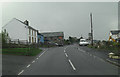
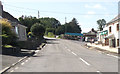
2
Road junction in Llanllwni
A minor road descending from the uplands of Mynydd Llanllwni meets the A485.
Image: © Nigel Brown
Taken: 17 Sep 2015
0.02 miles
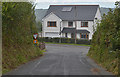
3
Siop y Pentre Llanllwni Village Store
Siop y Pentre / Swyddfa'r Post Llanllwni. Shop and Post Office in Llanllwni.
Image: © dave emery
Taken: 23 Dec 2008
0.05 miles
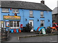
6
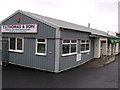
Hardware Store - Llanllwni
Lovely, welcoming and very old fashioned accountancy.
Image: © Peter Conroy
Taken: 12 Jan 2007
0.10 miles
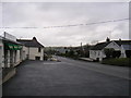
7
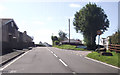
A485 at Tegfan Garage
North side of Llanllwni
Image: © John Firth
Taken: 5 Sep 2012
0.11 miles