IMAGES TAKEN NEAR TO
Cwm Cou, NEWCASTLE EMLYN, SA38 9NZ
Introduction
This page details the photographs taken nearby to SA38 9NZ by members of the Geograph project.
The Geograph project started in 2005 with the aim of publishing, organising and preserving representative images for every square kilometre of Great Britain, Ireland and the Isle of Man.

There are currently over 7.5m images from over14,400 individuals and you can help contribute to the project by visiting https://www.geograph.org.uk
Image Map
Images are licensed for reuse under creativecommons.org/licenses/by-sa/2.0
Notes
- Clicking on the map will re-center to the selected point.
- The higher the marker number, the further away the image location is from the centre of the postcode.
Image Listing (12 Images Found)
Images are licensed for reuse under creativecommons.org/licenses/by-sa/2.0
Image
Details
Distance
1
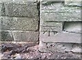
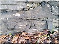
Ordnance Survey Cut Mark
This OS cut mark can be found on the wall south side of the road. It marks a point 30.331m above mean sea level.
Image: © Adrian Dust
Taken: 7 Jun 2021
0.03 miles
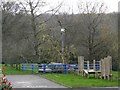
2
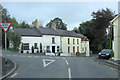
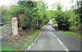
B4570 junction with Cwm-cou High Street
Image: © Stuart Logan
Taken: 8 Oct 2011
0.08 miles
3
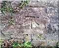
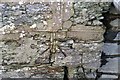
Ordnance Survey Cut Mark
This OS cut mark can be found on the north parapet of the bridge. It marks a point 22.085m above mean sea level.
Image: © Adrian Dust
Taken: 2 Mar 2020
0.09 miles
4
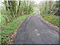
Lane over the old bridge at Pont-Ceri
Now a footpath and obviously used by locals to access other parts of the village and Cwm-Cou.
Image: © Jeremy Bolwell
Taken: 14 Apr 2011
0.09 miles
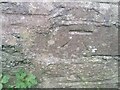
6
Ordnance Survey Cut Mark
This OS cut mark can be found on the NE parapet of the bridge. It marks a point 33.990m above mean sea level.
Image: © Adrian Dust
Taken: 2 Mar 2020
0.14 miles
7
Ordnance Survey Cut Mark
This OS cut mark can be found on the building east side of the road. It marks a point 23.960m above mean sea level.
Image: © Adrian Dust
Taken: 2 Mar 2020
0.14 miles
8
Ordnance Survey Cut Mark
This OS cut mark can be found on the SE parapet of the bridge. It marks a point 22.150m above mean sea level.
Image: © Adrian Dust
Taken: 7 Jun 2021
0.16 miles
9
Weather Station
Trewen School Weather Station. Proudly recording the Welsh weather!
Image: © Dawn Faith Worrall
Taken: 18 Mar 2007
0.17 miles
10
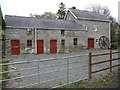
Old mill buildings at Trewen
What seems to be a range of buildings associated with the mill, plus a fine wheel.
Image: © Jeremy Bolwell
Taken: 14 Apr 2011
0.17 miles