IMAGES TAKEN NEAR TO
Tanglwst, NEWCASTLE EMLYN, SA38 9NH
Introduction
This page details the photographs taken nearby to Tanglwst, SA38 9NH by members of the Geograph project.
The Geograph project started in 2005 with the aim of publishing, organising and preserving representative images for every square kilometre of Great Britain, Ireland and the Isle of Man.

There are currently over 7.5m images from over14,400 individuals and you can help contribute to the project by visiting https://www.geograph.org.uk
Image Map
Images are licensed for reuse under creativecommons.org/licenses/by-sa/2.0
Notes
- Clicking on the map will re-center to the selected point.
- The higher the marker number, the further away the image location is from the centre of the postcode.
Image Listing (5 Images Found)
Images are licensed for reuse under creativecommons.org/licenses/by-sa/2.0
Image
Details
Distance
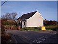
1

Tanglwst looking up hill
Tanglwst is a cluster of houses on the road junction to the left.
Image: © chris whitehouse
Taken: 21 Jun 2012
0.08 miles
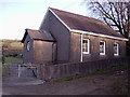
2
Tanglwst
Congregational Chapel. Built in 1870. Restored in 1954.
Image: © John Gillibrand
Taken: 21 Jan 2006
0.12 miles
3
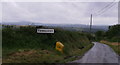
Tanglwst and salt/grit box
Exposed area, so in winter it could be difficult to get out of this village.
Image: © chris whitehouse
Taken: 21 Jun 2012
0.16 miles
4
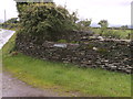
College, Tanglwst
This sign does state that this is a farm, but is it an educational farm?
Image: © chris whitehouse
Taken: 21 Jun 2012
0.20 miles