IMAGES TAKEN NEAR TO
Capel Iwan, NEWCASTLE EMLYN, SA38 9LS
Introduction
This page details the photographs taken nearby to SA38 9LS by members of the Geograph project.
The Geograph project started in 2005 with the aim of publishing, organising and preserving representative images for every square kilometre of Great Britain, Ireland and the Isle of Man.

There are currently over 7.5m images from over14,400 individuals and you can help contribute to the project by visiting https://www.geograph.org.uk
Image Map
Images are licensed for reuse under creativecommons.org/licenses/by-sa/2.0
Notes
- Clicking on the map will re-center to the selected point.
- The higher the marker number, the further away the image location is from the centre of the postcode.
Image Listing (8 Images Found)
Images are licensed for reuse under creativecommons.org/licenses/by-sa/2.0
Image
Details
Distance
1
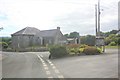
Capel Iwan Chapel & Village Square
The Chapel, wall, iron railings and gates are grade 2 listed, The Capel Iwan Square is actually trianglular in shape and has a modern telephone box and well planted flower bed adjacent. There is a war memorial on the square.
Image: © paul johnson
Taken: 20 Jun 2018
0.15 miles
2
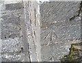
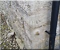
Ordnance Survey Cut Mark
This OS cut mark can be found on the east face of the chapel. It marks a point 156.638m above mean sea level.
Image: © Adrian Dust
Taken: 29 Feb 2020
0.16 miles
5

Capel Iwan
Public footpath leading down hill to the Afon Mamog.
Image: © Dawn Faith Worrall
Taken: 20 Feb 2007
0.20 miles
6
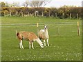
Llamas Grazing
These are two female llamas, both three years old. They are both pregnant. Though not indigenous to the British Isles, the llama's grazing habit is complementary when used in rotation with horses.
Image: © Dawn Faith Worrall
Taken: 9 Apr 2007
0.22 miles
7
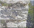
Ordnance Survey Cut Mark
This OS cut mark can be found on Pleasant View. It marks a point 168.285m above mean sea level.
Image: © Adrian Dust
Taken: 29 Feb 2020
0.24 miles
8
Ordnance Survey Cut Mark
This OS cut mark can be found on the east face of the school. It marks a point 146.249m above mean sea level.
Image: © Adrian Dust
Taken: 29 Feb 2020
0.25 miles