IMAGES TAKEN NEAR TO
Maes Nawmor, NEWCASTLE EMLYN, SA38 9JZ
Introduction
This page details the photographs taken nearby to Maes Nawmor, SA38 9JZ by members of the Geograph project.
The Geograph project started in 2005 with the aim of publishing, organising and preserving representative images for every square kilometre of Great Britain, Ireland and the Isle of Man.

There are currently over 7.5m images from over14,400 individuals and you can help contribute to the project by visiting https://www.geograph.org.uk
Image Map (Loading...)


Getting Data...Please wait
Leaflet Map data © OpenStreetMap
Images are licensed for reuse under creativecommons.org/licenses/by-sa/2.0
Notes
- Clicking on the map will re-center to the selected point.
- The higher the marker number, the further away the image location is from the centre of the postcode.
Image Listing (8 Images Found)
Images are licensed for reuse under creativecommons.org/licenses/by-sa/2.0
Image
Details
Distance
1
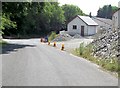
Buildings opposite entrance to Cenarth Falls Holiday Park
Image: © John Firth
Taken: 10 Jul 2013
0.08 miles

3
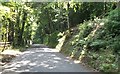
Through the woods north of Cenarth
Holiday camp is to the left
Image: © John Firth
Taken: 10 Jul 2013
0.12 miles
4
Willow sewin at Cenarth Primary School
This leaping salmon, or salmon trout (sewin), is the twin to the willow otter formerly to be seen at the Welsh Wildlife Centre at nearby Cilgerran, see Image
River fishing (and poaching!) is a traditional activity of the area.
Image: © Natasha Ceridwen de Chroustchoff
Taken: 4 Oct 2006
0.17 miles
5
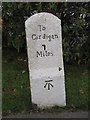
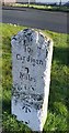
Old Milestone by the A484, Cenarth, Beulah parish
Cardigan tombstone by the A484, in parish of Beulah (Ceredigion District), Cenarth, beside footpath, Northeast side of road.
Inscription reads:-
To
Cardigan
7
Miles
Carved bench mark on lower face.
Grade II listed by Cadw.
Reference Number: 17947 https://cadwpublic-api.azurewebsites.net/reports/listedbuilding/FullReport?lang=&id=17947
Surveyed
Milestone Society National ID: CRD_CACM07
Image: © Milestone Society
Taken: Unknown
0.19 miles
6
Milestone - Cardigan 7
The OS cut mark on the stone marks a point 17.593m above mean sea level.
Image: © Adrian Dust
Taken: 2 Mar 2020
0.19 miles
7
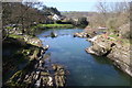
River Teifi
View downstream from the road bridge below Cenarth Falls
Image: © Roger Whittleston
Taken: 4 Apr 2007
0.21 miles
8
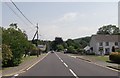
A484 through Cenarth
The garage can be seen on the left hand side
Image: © John Firth
Taken: 10 Jul 2013
0.23 miles