IMAGES TAKEN NEAR TO
NEWCASTLE EMLYN, SA38 9EW
Introduction
This page details the photographs taken nearby to SA38 9EW by members of the Geograph project.
The Geograph project started in 2005 with the aim of publishing, organising and preserving representative images for every square kilometre of Great Britain, Ireland and the Isle of Man.

There are currently over 7.5m images from over14,400 individuals and you can help contribute to the project by visiting https://www.geograph.org.uk
Image Map
Images are licensed for reuse under creativecommons.org/licenses/by-sa/2.0
Notes
- Clicking on the map will re-center to the selected point.
- The higher the marker number, the further away the image location is from the centre of the postcode.
Image Listing (7 Images Found)
Images are licensed for reuse under creativecommons.org/licenses/by-sa/2.0
Image
Details
Distance
1
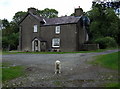
Blaenant
Farm at the top of the old carriage road leading down to Llandyfriog.
Image: © Natasha Ceridwen de Chroustchoff
Taken: 12 Aug 2008
0.01 miles
2
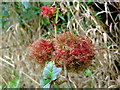
Rose bedeguar galls
An example of the rose gall, more often known as a robin's pincushion. The gall is created by the plant in response to an attack by the larvae of a gall wasp (Diplolepsis rosae) which then live in and feed on the resulting formation until emergence. In fact a recent study revealed that up to 17 different species had been found to inhabit bedeguars, some being inquilines - that is, larvae that use the gall without having formed it themselves - as well as parasites that feed on the larvae in situ.
For information on the rose gall research project see http://www.british-galls.org.uk/bedeguar.htm
The bedeguar is not of itself harmful to the plant.
Image: © Natasha Ceridwen de Chroustchoff
Taken: 12 Aug 2008
0.11 miles
3
Ordnance Survey Pivot
This OS pivot can be found on the wall north side of the road. It marks a point 134.111m above mean sea level.
Image: © Adrian Dust
Taken: 29 Feb 2020
0.13 miles
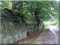
4
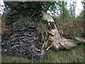
Bankrupt?
Old stonework and living tree roots are locked together in close embrace all the way down the banks of this green lane, making it hard to determine which is holding up what.
Image: © Natasha Ceridwen de Chroustchoff
Taken: 12 Aug 2008
0.16 miles
5
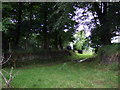
Green lane junction
South of Blaenant the old carriage road is joined by another leading to/from Old Cilgwyn. A spring rises here, according to the map.
Image: © Natasha Ceridwen de Chroustchoff
Taken: 12 Aug 2008
0.21 miles
6

Wind turbine
Wind turbine near Blaenant
Image: © Marion Phillips
Taken: 18 Feb 2016
0.22 miles
7
Rocky road
In places this green lane, which may have once been a carriage route, seems to have been cut through solid bedrock, topped by mature trees.
Image: © Natasha Ceridwen de Chroustchoff
Taken: 12 Aug 2008
0.23 miles