IMAGES TAKEN NEAR TO
Carmarthen Road, NEWCASTLE EMLYN, SA38 9BZ
Introduction
This page details the photographs taken nearby to Carmarthen Road, SA38 9BZ by members of the Geograph project.
The Geograph project started in 2005 with the aim of publishing, organising and preserving representative images for every square kilometre of Great Britain, Ireland and the Isle of Man.

There are currently over 7.5m images from over14,400 individuals and you can help contribute to the project by visiting https://www.geograph.org.uk
Image Map
Images are licensed for reuse under creativecommons.org/licenses/by-sa/2.0
Notes
- Clicking on the map will re-center to the selected point.
- The higher the marker number, the further away the image location is from the centre of the postcode.
Image Listing (11 Images Found)
Images are licensed for reuse under creativecommons.org/licenses/by-sa/2.0
Image
Details
Distance
1
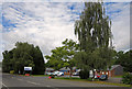
Industrial estate on the site of Newcastle Emlyn railway station
Image: © Dylan Moore
Taken: 1 Sep 2016
0.09 miles
2
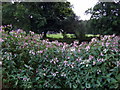
Alien invader in Castle Meadow
Across the river, which here describes an ox-bow bend around the castle site, the playing fields can barely be glimpsed through the screen of Himalayan Balsam (Impatiens glandifolia) that has been allowed to colonize the banks of the Teifi, with no apparent attempt to control it. Although quite a pretty plant, with its flowers ranging from deepest to palest pink, it is very invasive and suppresses the growth of indigenous species which would be more attractive in this location.
Image: © Natasha Ceridwen de Chroustchoff
Taken: 12 Aug 2008
0.15 miles
3
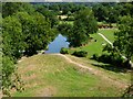
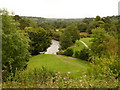
View from the Castle, Newcastle Emlyn
The Afon Teifi loops round the elevated site of the castle ruins, surrounding them on three sides.
Image: © Stephen McKay
Taken: 24 Jul 2006
0.17 miles
4
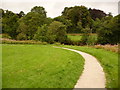
Castle Meadow, Newcastle Emlyn
Stand of trees in a prettily developed area of park-land surrounded by the rushing river.
Image: © Dylan Moore
Taken: 23 Oct 2013
0.22 miles
5
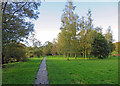
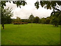
Newcastle Emlyn: tip of a Carmarthenshire tongue
The bends in the River Teifi form a long narrow piece of land, very much resembling a tongue in shape, on which the castle stands. Here we look along the path that goes round the very tip of the 'tongue', in a meadowy setting which incorporates a picnic area.
Since the river forms the county boundary, this is a long, thin appendage to the shape of Carmarthenshire, surrounded by Ceredigion.
Image: © Chris Downer
Taken: 19 Aug 2010
0.22 miles
6
Newcastle Emlyn: open space beyond the castle
Looking back towards the castle (though it is not visible) from near the end of the sort of peninsula formed by a tight bend in the River Teifi.
Image: © Chris Downer
Taken: 19 Aug 2010
0.22 miles
7
Milestone - Carmarthen 18
Metal milestone on NW side of road.
Image: © Adrian Dust
Taken: 12 Mar 2015
0.23 miles
8
Newcastle Emlyn: view from the castle mound
Looking across one arm of the River Teifi, which has flowed away from us to our right, round a tight bend and back towards us as we see it now.
Image: © Chris Downer
Taken: 19 Aug 2010
0.24 miles
9
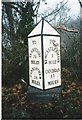
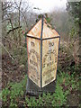
Old Milepost by the A484 east of Newcastle Emlyn
Carmarthen pyramid by the A484, in parish of Newcastle Emlyn (Carmarthenshire District), West of Gilwen Farm.
Inscription reads:-
: TO / LLANDYSIL / 7½ / MILES / CARMARTHEN / 18 / MILES : : NEWCASTLEEMLYN / 1 / MILE / CARDIGAN / 11 / MILES :
Grade II listed by Cadw.
Reference Number: 9697 https://cadwpublic-api.azurewebsites.net/reports/listedbuilding/FullReport?lang=&id=9697
Surveyed
Milestone Society National ID: CAM_CMCA18
Image: © Milestone Society
Taken: Unknown
0.24 miles
10
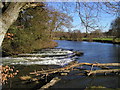
The river weir near the castle at Newcastle Emlyn
Seen on a calm crisp winter's day. For a view of the same spot with the river running higher and more strongly see Image]
Image: © John Brightley
Taken: 19 Feb 2004
0.24 miles