IMAGES TAKEN NEAR TO
Trem-y-Ddol, NEWCASTLE EMLYN, SA38 9AY
Introduction
This page details the photographs taken nearby to Trem-y-Ddol, SA38 9AY by members of the Geograph project.
The Geograph project started in 2005 with the aim of publishing, organising and preserving representative images for every square kilometre of Great Britain, Ireland and the Isle of Man.

There are currently over 7.5m images from over14,400 individuals and you can help contribute to the project by visiting https://www.geograph.org.uk
Image Map (Loading...)


Getting Data...Please wait
Leaflet Map data © OpenStreetMap
Images are licensed for reuse under creativecommons.org/licenses/by-sa/2.0
Notes
- Clicking on the map will re-center to the selected point.
- The higher the marker number, the further away the image location is from the centre of the postcode.
Image Listing (8 Images Found)
Images are licensed for reuse under creativecommons.org/licenses/by-sa/2.0
Image
Details
Distance
1
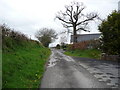
Oak tree on the lane
Now surrounded by housing this old oak has been lopped but still manages to look noble, dignified and natural.
Image: © Jeremy Bolwell
Taken: 14 Apr 2011
0.05 miles
2
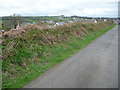
Lane above Newcastle Emlyn
This lane has nice views over a horse paddock towards distant Adpar on the other side of the Teifi valley. The horse spotted me and was temporarily intrigued.
Image: © Jeremy Bolwell
Taken: 14 Apr 2011
0.06 miles
4
Bed and Breakfast
Complete with massive monkey-puzzle tree and stone lions - this must have been built as a very grand residence on the Cardigan Road.
Image: © Natasha Ceridwen de Chroustchoff
Taken: 19 May 2008
0.07 miles
5
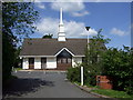
Mormon church
The church of Jesus Christ of the Latter Day Saints on the outskirts of Newcastle Emlyn.
Image: © Natasha Ceridwen de Chroustchoff
Taken: 19 May 2008
0.08 miles
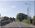
6
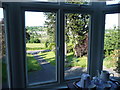
Looking out from the Maes-y-derw B&B onto the main Cardigan Road
Taken from the Tywy bedroom, this is the view from inside the B&B with the monkey-puzzle tree as taken by ceridwen. Interestingly, it was taken only 2 weeks after the other photo!
Image: © Marion Haworth
Taken: 12 Jun 2008
0.10 miles
7
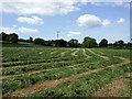
Fresh mown grass
The field has been newly mown for silage on the hillslope above the Teifi valley.
Image: © Natasha Ceridwen de Chroustchoff
Taken: 19 May 2008
0.11 miles
8
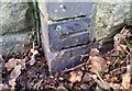
Ordnance Survey Cut Mark
This OS cut mark can be found on the corner of the cemetery wall. It marks a point 34.985m above mean sea level.
Image: © Adrian Dust
Taken: 2 Mar 2020
0.19 miles