IMAGES TAKEN NEAR TO
GLOGUE, SA36 0EF
Introduction
This page details the photographs taken nearby to SA36 0EF by members of the Geograph project.
The Geograph project started in 2005 with the aim of publishing, organising and preserving representative images for every square kilometre of Great Britain, Ireland and the Isle of Man.

There are currently over 7.5m images from over14,400 individuals and you can help contribute to the project by visiting https://www.geograph.org.uk
Image Map
Images are licensed for reuse under creativecommons.org/licenses/by-sa/2.0
Notes
- Clicking on the map will re-center to the selected point.
- The higher the marker number, the further away the image location is from the centre of the postcode.
Image Listing (3 Images Found)
Images are licensed for reuse under creativecommons.org/licenses/by-sa/2.0
Image
Details
Distance
1
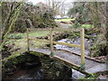
Pompren Melin y Glog / Melin y Glog footbridge
Pombren yn rychwantu Afon Taf ym Melin y Glog ger Tegryn.
Footbridge crossing the Taf River at Glogue Mill near Tegryn.
Image: © Alan Richards
Taken: 16 Dec 2009
0.16 miles
2
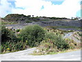
Old slate quarry at Glogue
Slate extraction probably started here in a small way at the end of the C18 but output only picked up in the 1820s and 30s. It grew substantially during the second half of the C19, peaking in 1873 when 80 men were employed, producing 2000 tons of slate a year. It was also in 1873 that the railway finally opened, with the purpose of easing the transport out.
Production slowed down in the C20 and the quarry was worked by a local syndicate until it closed in 1926.
Image: © Natasha Ceridwen de Chroustchoff
Taken: 12 Aug 2007
0.23 miles
3
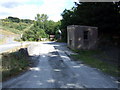
Weighbridge at Glogue quarry
Looking east along the floor of the quarry - there were in fact two quarries but they appear to have merged.
The weighbridge is probably for use by lorries taking out stone and rubble from the spoil heaps.
Image: © Natasha Ceridwen de Chroustchoff
Taken: 12 Aug 2007
0.24 miles