IMAGES TAKEN NEAR TO
Trinity Close, SWANSEA, SA3 5SX
Introduction
This page details the photographs taken nearby to Trinity Close, SA3 5SX by members of the Geograph project.
The Geograph project started in 2005 with the aim of publishing, organising and preserving representative images for every square kilometre of Great Britain, Ireland and the Isle of Man.

There are currently over 7.5m images from over14,400 individuals and you can help contribute to the project by visiting https://www.geograph.org.uk
Image Map
Images are licensed for reuse under creativecommons.org/licenses/by-sa/2.0
Notes
- Clicking on the map will re-center to the selected point.
- The higher the marker number, the further away the image location is from the centre of the postcode.
Image Listing (93 Images Found)
Images are licensed for reuse under creativecommons.org/licenses/by-sa/2.0
Image
Details
Distance
1
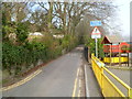
Southern end of Limekiln Road, Mumbles
Limekiln Road heads away from Newton Road towards Castle Road. The edge of Oystermouth Primary School is on the right.
Image: © Jaggery
Taken: 11 Mar 2012
0.05 miles
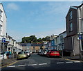
2
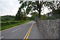
The Mumbles : Newton Road
A road heading out from The Mumbles.
Image: © Lewis Clarke
Taken: 12 Aug 2017
0.09 miles
3
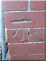
Ordnance Survey Cut Mark
This OS cut mark can be found on the NW angle of the Infants School. It marks a point 24.680m above mean sea level.
Image: © Adrian Dust
Taken: 9 Feb 2016
0.09 miles
4
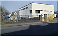
Southern side of Oystermouth Primary School, Mumbles
Viewed across Newton Road from near the corner of Stanley Street.
The school occupies a long, narrow site on the east side of Limekiln Road.
Image: © Jaggery
Taken: 11 Mar 2012
0.09 miles
5
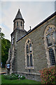
The Mumbles : Baptist Church
Mumbles Baptist Church was formed in 1910. The current minister is Rev. Andrew Davies, who was inducted at the start of 2006. Past ministers include Rev. Tom Griffiths and Rev. Gareth Hutchinson.
Image: © Lewis Clarke
Taken: 12 Aug 2017
0.09 miles
6
Mumbles Baptist Church, Swansea
The Langland Road side of the church on the corner of Newton Road. http://www.geograph.org.uk/photo/2845759 to another view.
Image: © Jaggery
Taken: 12 Sep 2014
0.09 miles
7
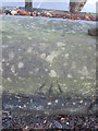
Ordnance Survey Rivet
This OS rivet can be found on the wall of the Infants School. It marks a point 96.478m above mean sea level.
Image: © Adrian Dust
Taken: 9 Feb 2016
0.09 miles
8
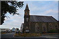
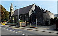
The Mumbles : Baptist Church
Mumbles Baptist Church was formed in 1910. The current minister is Rev. Andrew Davies, who was inducted at the start of 2006. Past ministers include Rev. Tom Griffiths and Rev. Gareth Hutchinson.
Image: © Lewis Clarke
Taken: 12 Aug 2017
0.10 miles
9

Mumbles Baptist Church, Swansea
Located on the corner of Newton Road and Langland Road, Mumbles. The church was built in 1910.
Image: © Jaggery
Taken: 11 Mar 2012
0.11 miles
10
Castle Square, Mumbles, Swansea
Looking north from Newton Road.
Image: © Jaggery
Taken: 12 Sep 2014
0.11 miles