IMAGES TAKEN NEAR TO
Fulmar Close, SWANSEA, SA3 5RD
Introduction
This page details the photographs taken nearby to Fulmar Close, SA3 5RD by members of the Geograph project.
The Geograph project started in 2005 with the aim of publishing, organising and preserving representative images for every square kilometre of Great Britain, Ireland and the Isle of Man.

There are currently over 7.5m images from over14,400 individuals and you can help contribute to the project by visiting https://www.geograph.org.uk
Image Map
Images are licensed for reuse under creativecommons.org/licenses/by-sa/2.0
Notes
- Clicking on the map will re-center to the selected point.
- The higher the marker number, the further away the image location is from the centre of the postcode.
Image Listing (8 Images Found)
Images are licensed for reuse under creativecommons.org/licenses/by-sa/2.0
Image
Details
Distance
1
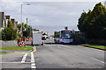
Bus waiting point at the top of the West Cross Estate
The bus route 3A comes right to the top of the estate and waits here to align with the timetable. Swansea Bay can be seen below, if a bit grey.
Image: © Bill Boaden
Taken: 6 Apr 2016
0.10 miles
2
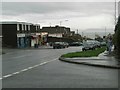
Local shops
Near the top of West Cross Lane.
Image: © Jennifer Luther Thomas
Taken: 24 Nov 2006
0.11 miles
4
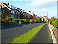
Southlands Drive, Newton
These houses enjoy a spectacular view across Swansea Bay, see Image
Image: © Jonathan Billinger
Taken: 12 Nov 2008
0.13 miles
5
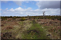
Path heading for the edge of Clyne Common
From experience on this occasion, the edges of the common are more waterlogged than the middle.
Image: © Bill Boaden
Taken: 6 Apr 2016
0.16 miles
6
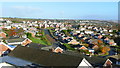
The Mumbles housing estates
Looking north from Southlands Drive.
Image: © Jonathan Billinger
Taken: 12 Nov 2008
0.16 miles
7
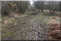
Path on Clyne Common
This shows the current state of this part of the common as fairly waterlogged. Ahead are some of the houses on the Chestnut Avenue estate.
Image: © Bill Boaden
Taken: 6 Apr 2016
0.23 miles
8
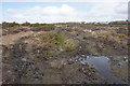
Path on Clyne Common
It doesn't look too bad on this image, but this part of Clyne Common is currently fairly waterlogged, making me think I might adjust my route.
Image: © Bill Boaden
Taken: 6 Apr 2016
0.23 miles