IMAGES TAKEN NEAR TO
Kenilworth Place, SWANSEA, SA3 5LL
Introduction
This page details the photographs taken nearby to Kenilworth Place, SA3 5LL by members of the Geograph project.
The Geograph project started in 2005 with the aim of publishing, organising and preserving representative images for every square kilometre of Great Britain, Ireland and the Isle of Man.

There are currently over 7.5m images from over14,400 individuals and you can help contribute to the project by visiting https://www.geograph.org.uk
Image Map (Loading...)


Getting Data...Please wait
Leaflet Map data © OpenStreetMap
Images are licensed for reuse under creativecommons.org/licenses/by-sa/2.0
Notes
- Clicking on the map will re-center to the selected point.
- The higher the marker number, the further away the image location is from the centre of the postcode.
Image Listing (24 Images Found)
Images are licensed for reuse under creativecommons.org/licenses/by-sa/2.0
Image
Details
Distance
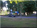
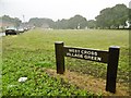
1
View of The Mumbles from Fairwood Avenue - West Cross
Image: © Mick Lobb
Taken: 21 Jul 2010
0.04 miles
2
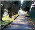
Tree-lined entrance drive to Territorial Army Centre, West Cross, Swansea
Viewed from the edge of the A4076 Mumbles Road, where signs shows that the Centre is the home of
223 (West Glamorgan) Transport Squadron, (part of the Welsh Transport Regiment, The Royal Logistic Corps (Volunteers)),
The Grange Detachment of the Glamorgan Army Cadet Force and
The headquarters of No 3 Welsh Wing, Air Training Corps 1998 Squadron West Cross.
Image: © Jaggery
Taken: 26 Feb 2012
0.14 miles
3
Lilliput Lane, West Cross, Swansea
Viewed from the edge of Gulliver's Close. Lilliput is the island country inhabited by a race of tiny people, less than 6 inches tall, visited by Lemuel Gulliver in Jonathan Swift's 18th century novel Gulliver's Travels.
Image: © Jaggery
Taken: 26 Feb 2012
0.14 miles
4
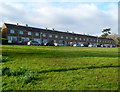
Long row of houses, Heathwood Road, West Cross, Swansea
The row extends for 90 metres.
Image: © Jaggery
Taken: 26 Feb 2012
0.15 miles
6
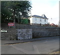
Dan-y-Coed House, Swansea
Owned by the City and County of Swansea Council, Dan-y-Coed House in Huntington Close,
West Cross, Swansea is a venue for small conferences and training events.
Image: © Jaggery
Taken: 26 Feb 2012
0.19 miles
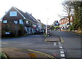
8
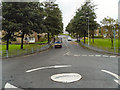
Fairwood Road/Mumbles Road
Mini roundabout at the junction of Fairwood Road with Mumbles Road (A4067).
Image: © David Dixon
Taken: 29 Aug 2012
0.21 miles
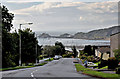
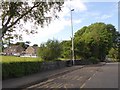
9
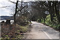
West Cross : Swansea Bay Cycle Path
The cycle path heading from here towards the Mumbles.
Image: © Lewis Clarke
Taken: 23 Mar 2014
0.21 miles